Search
You Searched For
Search Results
- Creator:
- Bowen, Emanuel, d. 1767
Cook, James, fl. 1766, creator
- Published / Created:
- Decr. 1766
- Call Number:
- 2003 Folio 85
- Image Count:
- 1
- Found in:
- Beinecke Rare Book and Manuscript Library > A draught of Port Royal Harbour in South Carolina: with the marks for going in : most humbly inscribed to the publick
- Creator:
- Bowen, Emanuel, d. 1767
Cook, James, 1728-1779, creator
- Published / Created:
- Decem'r. 1766
- Call Number:
- 2003 Folio 85
- Image Count:
- 1
- Found in:
- Beinecke Rare Book and Manuscript Library > A draught of the harbour of Halifax and the adjacent coast in Nova Scotia: surveyed by order of Commodore Spry
- Creator:
- Bowen, Emanuel, d. 1767
- Published / Created:
- 1754
- Call Number:
- 75 1720
- Container / Volume:
- BRBL_00689
- Image Count:
- 1
- Resource Type:
- Maps, Atlases & Globes
- Found in:
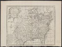
- Beinecke Rare Book and Manuscript Library > A map of the British American plantations [cartographic material] : extending from Boston in New England to Georgia, including all the back settlements in the respective provinces, as far as the Mississippi / by Eman. Bowen Geogr. to His Majesty ; Tho. Bo
- Creator:
- Bowen, Emanuel, d. 1767
- Published / Created:
- 1752?]
- Call Number:
- 71 1752B
- Container / Volume:
- BRBL_00725
- Image Count:
- 1
- Resource Type:
- Maps, Atlases & Globes
- Found in:
- Beinecke Rare Book and Manuscript Library > A new & accurate map of Louisiana, with part of Florida and Canada, and the adjacent countries / drawn from surveys, assisted by the most approved English & French maps & charts, the whole being regulated by astronl. observations. By Eman. Bowen.
- Creator:
- Bowen, Emanuel, d. 1767
- Published / Created:
- 1752?]
- Call Number:
- 71 1752
- Container / Volume:
- BRBL_00362
- Image Count:
- 1
- Resource Type:
- Maps, Atlases & Globes
- Found in:
- Beinecke Rare Book and Manuscript Library > A new & accurate map of Louisiana, with part of Florida and Canada, and the adjacent countries / drawn from surveys, assisted by the most approved English & French maps & charts, the whole being regulated by astronl. observations. By Eman. Bowen.
- Creator:
- Bowen, Emanuel, d. 1767
- Published / Created:
- 1747]
- Call Number:
- 8555 1747
- Container / Volume:
- BRBL_00642
- Image Count:
- 1
- Resource Type:
- Maps, Atlases & Globes
- Found in:
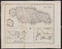
- Beinecke Rare Book and Manuscript Library > A new & accurate map of the Island of Jamaica [cartographic material] : divided into its principal parishes / drawn from surveys, and regulated by astronl. observatns. by Eman. Bowen.
- Creator:
- Bowen, Emanuel, d. 1767
- Published / Created:
- 1747]
- Call Number:
- 8555 1752A
- Container / Volume:
- BRBL_00695
- Image Count:
- 1
- Resource Type:
- Maps, Atlases & Globes
- Found in:
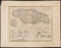
- Beinecke Rare Book and Manuscript Library > A new & accurate map of the Island of Jamaica [cartographic material] : divided into its principal parishes / drawn from surveys, and regulated by astronl. observatns. by Eman. Bowen.
- Creator:
- Bowen, Emanuel, d. 1767
- Published / Created:
- 1747]
- Call Number:
- 855 1747
- Container / Volume:
- BRBL_00695
- Image Count:
- 1
- Resource Type:
- Maps, Atlases & Globes
- Found in:
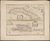
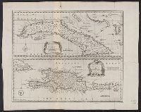
- Beinecke Rare Book and Manuscript Library > A new & accurate map of the island of Cuba ; A new & accurate map of the islands of Hispaniola or St. Domingo, and Porto Rico / [cartographic material] / drawn from the most approved maps & charts, and regulated by astronl. observations by Eman. Bowen.
- Creator:
- Bowen, Emanuel, d. 1767
- Published / Created:
- 1750?]
- Call Number:
- 855 1750
- Container / Volume:
- BRBL_00641
- Image Count:
- 1
- Resource Type:
- Maps, Atlases & Globes
- Found in:
- Beinecke Rare Book and Manuscript Library > A new & accurate map of the island of Cuba ; A new & accurate map of the islands of Hispaniola or St. Domingo, and Porto Rico / [cartographic material] / drawn from the most approved maps & charts, and regulated by astronl. observations by Eman. Bowen.
- Creator:
- Bowen, Emanuel, d. 1767
- Call Number:
- 623 1750
- Container / Volume:
- BRBL_00333
- Image Count:
- 1
- Resource Type:
- Maps, Atlases & Globes
- Found in:
- Beinecke Rare Book and Manuscript Library > A new and accurate map of Nubia & Abissinia, together with all the kingdoms tributary thereto, and bordering upon them / laid down from the latest & best authorities and regulated by astronl. observations ny Emanl. Bowen.
- Creator:
- Bowen, Emanuel, d. 1767
- Published / Created:
- [London : and 1747]
- Call Number:
- 57 1747
- Container / Volume:
- BRBL_00301
- Image Count:
- 1
- Resource Type:
- Maps, Atlases & Globes
- Found in:
- Beinecke Rare Book and Manuscript Library > A new and accurate map of the Empire of Japan : laid down from the memoirs of the Portuguese and Dutch, and particularly from the Jesuit missionaries, as publish'd by the Sr. Bellin at Paris : being adjusted by astronomical observatns. / by Eman. Bowen.
- Creator:
- Bowen, Emanuel, d. 1767
- Published / Created:
- ca. 1750]
- Call Number:
- 73 1752
- Container / Volume:
- BRBL_00373
- Image Count:
- 1
- Resource Type:
- Maps, Atlases & Globes
- Found in:
- Beinecke Rare Book and Manuscript Library > A new and accurate map of the Islands of Newfoundland, Cape Breton, St. John and Anticosta : together with the neighbouring countries of Nova Scotia, Canada &c. Drawn from the most approved modern maps and charts, and regulated by astron. observat. / by E
- Creator:
- Bowen, Emanuel, d. 1767
- Published / Created:
- 1747]
- Call Number:
- 8612 1747
- Container / Volume:
- BRBL_00696
- Image Count:
- 1
- Resource Type:
- Maps, Atlases & Globes
- Found in:
- Beinecke Rare Book and Manuscript Library > A new and accurate map of the island of Antigua or Antego [cartographic material] : taken from surveys, and adjusted by astronl. observations : containing all the towns, parish churches, forts, castles, windmills, roads &c. / by Eman. Bowen.
- Creator:
- Bowen, Emanuel, d. 1767
- Published / Created:
- 1752]
- Call Number:
- 73 1752A
- Container / Volume:
- BRBL_00373
- Image Count:
- 1
- Resource Type:
- Maps, Atlases & Globes
- Found in:
- Beinecke Rare Book and Manuscript Library > A new and accurate map of the islands of Newfoundland, Cape Breton, St. John and Anticosta : together with the neighbouring countries of Nova Scotia, Canada, &c. / drawn from the most approved modern maps and charts and regulated by Astronl. observatns. b
- Creator:
- Bowen, Emanuel, d. 1767
- Published / Created:
- 1752
- Call Number:
- 1978 Folio 142
- Collection Title:
- A complete atlas, or distinct view of the known world; exhibited in sixty-eight maps ... in which
- Image Count:
- 1
- Found in:
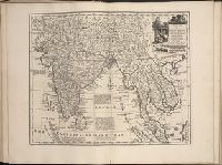
- Beinecke Rare Book and Manuscript Library > A new and accurate mapof the Empire of the Great Mogul, together with India on both sides the Ganges, and the adjacent countries. Drawn fromt he most approved modern maps and charts: The whole being regulated by Astron's observations by Eman. Bowen
- Creator:
- Bowen, Emanuel, d. 1767
- Published / Created:
- 1748
- Call Number:
- 49 1748
- Container / Volume:
- BRBL_00267
- Image Count:
- 1
- Resource Type:
- Maps, Atlases & Globes
- Found in:
- Beinecke Rare Book and Manuscript Library > An accurate chart of the Mediterranean and Adriatic Seas, with the archipelago & part of the Black Sea : exhibiting all the islands in those seas, as also, the adjacent countries on the continents of Europe, Africa & Asia / drawn from the most approved ma
- Creator:
- Bowen, Emanuel, d. 1767
Gibson, J. (John)
Overton, Henry, fl. 1706-1764
Sayer, Robert, 1725-1794
- Published / Created:
- [between 1755 and 1775?]
- Call Number:
- 2003 Folio 85
- Image Count:
- 1
- Found in:
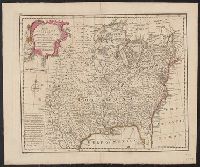
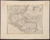
- Beinecke Rare Book and Manuscript Library > An accurate map of North America: describing and distinguishing the British, Spanish and French dominions on this great continent; exhibiting the present seat of war, and the French encroachments. Also all the West India Islands belonging to, and possesse
- Creator:
- Bowen, Emanuel, d. 1767
- Published / Created:
- 1747]
- Call Number:
- 85 1730A
- Container / Volume:
- BRBL_00692
- Image Count:
- 1
- Resource Type:
- Maps, Atlases & Globes
- Found in:
- Beinecke Rare Book and Manuscript Library > An accurate map of the West Indies [cartographic material] : drawn from the best authorities, assisted by the most approved modern maps and charts, and regulated by astronomical observations / by Eman: Bowen.
- Creator:
- Bowen, Emanuel, d. 1767
- Published / Created:
- 1747]
- Call Number:
- 867 1747
- Container / Volume:
- BRBL_00696
- Image Count:
- 1
- Resource Type:
- Maps, Atlases & Globes
- Found in:
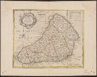
- Beinecke Rare Book and Manuscript Library > An accurate map of the island of Barbadoes [cartographic material] : drawn from an actual survey containing all the towns, churches, fortifications, roads, paths, plantations &c. / by Eman. Bowen.
- Creator:
- Bowen, Emanuel, d. 1767
- Published / Created:
- 1720
- Call Number:
- 1978 Folio 10
- Collection Title:
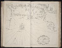
- The English pilot: describing the West-India navigation, from Hudson's-Bay to the river Amazones
- Image Count:
- 1
- Found in:
- Beinecke Rare Book and Manuscript Library > The harbour of Casco Bay and islands adjacent