Bowen, Thomas, d. 1790 Speer, Joseph Smith., creator
Published / Created:
1774 May 20
Call Number:
1982 Folio 10
Image Count:
1
Alternative Title:
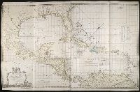
Chart of the West Indies
Description:
European possessions shown by color., Includes acknowledgement to Captain Speer by John Pownall, secry., Plantation Office, Whitehall, January 25, 1774 and Honorary gold medal., No. 41 of 43 maps bound together in composite atlas., Relief shown pictorially. Depths shown by soundings., Scale [ca. 1:5,000,000]., and Shows southern United States, Mexico, Central America, West Indies, Bermudas, and northern South America.
Publisher:
Capt. Speer
Subject (Geographic):
Caribbean Area --Maps --Early works to 1800 and West Indies --Maps --Early works to 1800