Search
You Searched For
Search Results
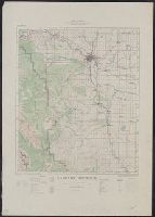
- Creator:
- Canada. Topographical Survey
- Published / Created:
- 1926
- Call Number:
- 737 C12 1926
- Container / Volume:
- BRBL_00385
- Image Count:
- 1
- Resource Type:
- Maps, Atlases & Globes
- Found in:
- Beinecke Rare Book and Manuscript Library > Calgary district.
- Creator:
- Canada. Topographical Survey
- Published / Created:
- 1929
- Call Number:
- 737FCM P312 1929
- Container / Volume:
- BRBL_00386
- Image Count:
- 1
- Resource Type:
- Maps, Atlases & Globes
- Found in:
- Beinecke Rare Book and Manuscript Library > Map of part of Peace River district, Province of Alberta, comprising parts of Peace River and Grande Prairie land districts : classification of lands by quarter sections for settlement purposes.
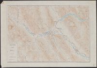
- Creator:
- Canada. Topographical Survey
- Published / Created:
- [19--?]
- Call Number:
- 737CBF B22 1925
- Container / Volume:
- BRBL_00386
- Image Count:
- 1
- Resource Type:
- Maps, Atlases & Globes
- Found in:
- Beinecke Rare Book and Manuscript Library > Map of Banff and vicinity / compiled and printed at the Surveyor General's Office.
- Creator:
- Canada. Topographical Survey
- Published / Created:
- 1923
- Call Number:
- 737 R59 1923
- Container / Volume:
- BRBL_00385
- Image Count:
- 1
- Resource Type:
- Maps, Atlases & Globes
- Found in:
- Beinecke Rare Book and Manuscript Library > Map of Rocky Mountains Park / compiled, drawn and printed by the Topographical Survey of Canada.
- Creator:
- Canada. Topographical Survey
- Published / Created:
- 1925
- Call Number:
- 737 L14 1925
- Container / Volume:
- BRBL_00385
- Image Count:
- 1
- Resource Type:
- Maps, Atlases & Globes
- Found in:
- Beinecke Rare Book and Manuscript Library > Plan of Lake Louise and vicinity [map] / drawn and printed by the Topographical Survey of Canada.
- Creator:
- Canada. Topographical Survey
- Published / Created:
- 1926
- Call Number:
- 737 Ed58 1926
- Container / Volume:
- BRBL_00385
- Image Count:
- 1
- Resource Type:
- Maps, Atlases & Globes
- Found in:
- Beinecke Rare Book and Manuscript Library > Edmonton district / drawn and printed at the office of the Topographical Survey of Canada, Department of the Interior, Ottawa, June 1926.
- Creator:
- Canada. Topographical Survey
- Published / Created:
- 1909]
- Call Number:
- 739B 1909
- Container / Volume:
- BRBL_00391
- Image Count:
- 1
- Resource Type:
- Maps, Atlases & Globes
- Found in:
- Beinecke Rare Book and Manuscript Library > Map of the boundary between the Province of British Columbia and Yukon Territory :bfrom Tatshenshini River to Teslin Lake.
- Creator:
- Canada. Topographical Survey
- Published / Created:
- 1925
- Call Number:
- 743 L79 1925
- Container / Volume:
- BRBL_00395
- Image Count:
- 1
- Resource Type:
- Maps, Atlases & Globes
- Found in:
- Beinecke Rare Book and Manuscript Library > Map of Lockhart River Basin, Great Slave Lake District, Northwest Territories : including the head waters of Thelon, Back and Coppermine Rivers / compiled, drawn and printed at the Topographical Survey of Canada.
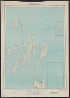
- Creator:
- Canada. Topographical Survey
- Published / Created:
- 1933
- Call Number:
- 744 B41 1933
- Container / Volume:
- BRBL_00395
- Image Count:
- 1
- Resource Type:
- Maps, Atlases & Globes
- Found in:
- Beinecke Rare Book and Manuscript Library > Belcher Islands, Northwest Territories [map] / compiled, drawn and printed ... by the Topographical Survey of Canada.
- Creator:
- Canada. Topographical Survey
- Published / Created:
- 1936
- Call Number:
- 743 C14 1936
- Container / Volume:
- BRBL_00395
- Image Count:
- 1
- Resource Type:
- Maps, Atlases & Globes
- Found in:
- Beinecke Rare Book and Manuscript Library > Cameron Bay, Northwest Territories [map] / compiled, drawn and printed ... by the Topographical Survey of Canada.