Date from entry in catalog of the Royal Geographical Society., Includes table "Methodical division of Italy.", Includes texts within the map explaining various political divisions and their histories., Includes three bar scales, onl, and Relief shown pictorially.
Publisher:
John Bowles ... and Carrington Bowles,
Subject (Geographic):
Italy--Maps--Early works to 1800
Subject (Name):
Bowles, Carington, 1724-1793, Bowles, John, 1701-1779, Kitchin, Thomas, d. 1784, and Palairet, Jean, 1697-1774
"Longit. west from Ferro I.", "Printed for John Bowles at the Black Horse in Cornhill & Carington Bowles in St. Pauls Church yard, London.", and Differs from other copy in coloration. Only boundaries are colored, emphasis is on showing the internal boundaries o
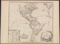
Publisher:
Printed for John Bowles,
Subject (Geographic):
North America--Maps--Early works to 1800
Subject (Name):
Bowles, Carington, 1724-1793, Bowles, John, 1701-1779, and Palairet, Jean, 1697-1774
Includes text and ill., Library's copy annotated in ink in upper right corner, "12"; and on verso, annotated "Amérique 12" and stamped "Yale, Horace Brown, 1900S.", Relief shown pictorially., and Shows boundaries of lands claimed by the English, French, Spanish
Publisher:
s.n.,
Subject (Geographic):
America--Maps--Early works to 1800
Subject (Name):
Anville, Jean Baptiste Bourguignon d', 1697-1782, Bayly, J, Bellin, Jacques Nicolas, 1703-1772, and Bowles, Thomas, -1767