- Creator:
- Des Barres, Joseph F. W. (Joseph Frederick Wallet), 1722-1824
- Published / Created:
- Augt. 1st, 1781.
- Call Number:
- 734 S46 1781
- Container / Volume:
- BRBL_00380
- Image Count:
- 1
- Resource Type:
- Maps, Atlases & Globes
- Description:
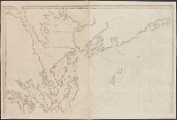
- Appears in the author's Atlantic neptune., Has watermark., Oriented with north to the right., Relief shown by hachures and shading. Depths shown by soundings., and Title supplied by cataloger.
- Publisher:
- J.F.W. Des Barres,
- Subject (Geographic):
- Sept-Iles (Québec)--Maps--Early works to 1800 and Seven Islands Bay (Québec)--Maps--Early works to 1800
- Subject (Name):
- Des Barres, Joseph F. W. (Joseph Frederick Wallet), 1722-1824. Atlantic neptune
- Subject (Topic):
- Harbors--Québec--Sept-Iles--Maps--Early works to 1800
- Found in:
- Beinecke Rare Book and Manuscript Library > [Bay of Seven Islands, Québec].
Search
Limit your search
- Public✖[remove]12
- Maps✖[remove]12
- English12
- Des Barres, Joseph F. W. (Joseph Frederick Wallet), 1722-1824✖[remove]12
- Nautical charts--Nova Scotia--Early works to 18003
- Coasts--Nova Scotia--Maps--Early works to 18002
- Coasts--New Brunswick--Maps--Early works to 18001
- Coasts--New Brunswick--Shediac Region--Maps--Early works to 18001
- Coasts--Québec (Province)--Gaspé Peninsula--Maps--Early works to 18001
- Harbors--New Brunswick--Maps--Early works to 18001
- Harbors--Nova Scotia--Early works to 18001
- Harbors--Nova Scotia--Liverpool Bay--Maps--Early works to 18001
- Harbors--Nova Scotia--Maps--Early works to 18001
- Harbors--Québec--Sept-Iles--Maps--Early works to 18001
Current results range from 1770 to 1789