"Augt. 20.th 1813"., Also covers eastern Long Island Sound and the eastern tip of Long Island. Extends west to Hammonasset Point, east to Watch Hill Point, R.I., and north to Norwich., Relief shown by hachures., and Sheet measures 41 x 45.5 cm.
Publisher:
A. Doolittle,
Subject (Geographic):
Long Island Sound (N.Y. and Conn.)--Maps, New London County (Conn.)--Maps, and New London Region (Conn.)--Maps
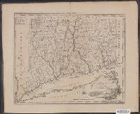
Appears in Mathew Carey's Carey's American pocket atlas., Mounted on linen. Sheet measures 26 x 19.4 cm. Cross Collection no. 204., Prime meridians: London and Philadelphia., and Relief shown pictorially.
"To the mayor, aldermen & common council of the city of New Haven, this plan is with all due respect most humbly dedicated by their most obedient humble servant, Amos Doolittle.", Copy 4 from drawer no. 15, New Haven region property maps., and Includes text
"To the mayor, aldermen & common council of the city of New Haven, this plan is with all due respect most humbly dedicated by their most obedient humble servant, Amos Doolittle.", Copy 4 from drawer no. 15, New Haven region property maps., and Includes text
"To the mayor, aldermen & common council of the city of New Haven, this plan is with all due respect most humbly dedicated by their most obedient humble servant, Amos Doolittle.", Copy 4 from drawer no. 15, New Haven region property maps., and Includes text
"To the mayor, aldermen & common council of the city of New Haven, this plan is with all due respect most humbly dedicated by their most obedient humble servant, Amos Doolittle.", Copy 4 from drawer no. 15, New Haven region property maps., and Includes text