Search
You Searched For
Search Results
- Creator:
- E. & G.W. Blunt (Firm)
- Published / Created:
- 1861
- Call Number:
- 754cea 1854
- Container / Volume:
- BRBL_00418
- Image Count:
- 1
- Resource Type:
- Maps, Atlases & Globes
- Found in:
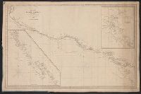
- Beinecke Rare Book and Manuscript Library > The coast of the United States sheet no. 1. : From Point Judith to Cape Lookout, from the U.S. Coast Surveys.
- Creator:
- E. & G.W. Blunt (Firm)
- Published / Created:
- 1849
- Call Number:
- 88cea 1849
- Container / Volume:
- BRBL_00648
- Image Count:
- 1
- Resource Type:
- Maps, Atlases & Globes
- Found in:
- Beinecke Rare Book and Manuscript Library > West coast of North America from the Gulf of Dulce to San Francisco.
- Creator:
- E. & G.W. Blunt (Firm)
- Published / Created:
- 1848
- Call Number:
- 71cea 1848
- Container / Volume:
- BRBL_00371
- Image Count:
- 1
- Resource Type:
- Maps, Atlases & Globes
- Found in:
- Beinecke Rare Book and Manuscript Library > West coast of North America from the Gulf of Dulce to San Francisco.
- Creator:
- E. & G.W. Blunt (Firm)
- Published / Created:
- [between 1827? and 1850?]
- Call Number:
- 21cea 1830
- Container / Volume:
- BRBL_00016
- Image Count:
- 1
- Resource Type:
- Maps, Atlases & Globes
- Found in:
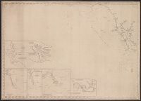
- Beinecke Rare Book and Manuscript Library > [Coast chart from Cape Hatteras to Cape Fear, North Carolina [cartographic material] : with insets of Cape Hatteras, Ocracoke Bar and Roads, Cape Lookout, Beaufort Harbour, Cape Fear, and the Cape Fear River] / engraved & printed by W. Hooker.