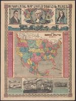
Ornamental map of the United States & Mexico and Ornamental map of the United States and Mexico
Description:
Includes text, portraits of Lafayette, Washington, and Franklin, "Panoramic view from New York to the Pacific Ocean by the contemplated Oregon railroad," and ill. of "Great Temple dedicated to the Sun," "An American exhibiting to the sovereins of Europe t
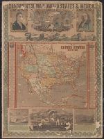
Ornamental map of the United States & Mexico and Ornamental map of the United States and Mexico
Description:
"Entered according to act of Congress in the year 1848 by Ensigns & Thayer in the clerk's office of the district court of the United States for the southern district of New York.", Date inferred from 1850 population figures given in text., and Includes text, po
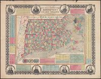
"Entered according to act of Congress in the year 1855 by Ensign, Bridgman & Fanning ..." and Border includes 8 portraits (John Hancock, Cotton Mather, Daniel Webster, Roger Williams, Gov. Trumbull, Timothy Dwight, O. Ellsworth, and Gen. Greene), 3 vignettes,
Publisher:
Ensign, Bridgman & Fanning,
Subject (Geographic):
Boston (Mass.)--Maps, Connecticut--Maps, Massachusetts--Maps, and Rhode Island--Maps
Subject (Topic):
Cities and towns--Connecticut--Maps, Cities and towns--Massachusetts--Maps, and Cities and towns--Rhode Island--Maps
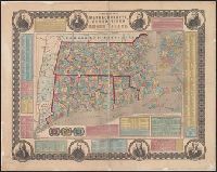
"Entered according to act of Congress in the year 1855 by Ensign, Bridgman & Fanning ...", Border includes 8 portraits (J, Hand colored by township. State and county borders outlined., Inset: "Boston.", and Prime meridian: Washington (top) and Greenwich (bottom).
Publisher:
Ensign, Bridgman & Fanning,
Subject (Geographic):
Boston (Mass.)--Maps, Connecticut--Maps, Massachusetts--Maps, and Rhode Island--Maps
Subject (Topic):
Cities and towns--Connecticut--Maps, Cities and towns--Massachusetts--Maps, and Cities and towns--Rhode Island--Maps