1. A general map of the middle British colonies in America : viz. Virginia, Maryland, Delaware Creator: Evans, Lewis, 1700?-1756 Published / Created: 1771 Call Number: 755 1771C Container / Volume: BRBL_00429 Image Count: 1 Resource Type: Maps, Atlases & Globes Found in: Beinecke Rare Book and Manuscript Library > A general map of the middle British colonies in America : viz. Virginia, Maryland, Delaware, Pensilvania, New-Jersey, New York, Connecticut & Rhode-Island : of Aquanishuonigy the country of the confederate Indians comprehending Aquanishuonigy proper, thei
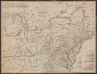
2. Bowles's new one-sheet map of the independent states of Virginia, Maryland, Delaware, Pensylvania Creator: Evans, Lewis, 1700?-1756 Published / Created: [1796] Call Number: 755 1796B Container / Volume: BRBL_00436 Image Count: 1 Resource Type: Maps, Atlases & Globes Found in: Beinecke Rare Book and Manuscript Library > Bowles's new one-sheet map of the independent states of Virginia, Maryland, Delaware, Pensylvania, New Jersey, New York, Connecticut, Rhode Island, &c. : comprehending also the habitations & hunting countries of the confederate Indians / by Lewis Evans.