Skip to search
Skip to main content
Skip to first result
Search
You Searched For
Extent of Digitization
Completely digitized
Format
cartographic
Genre
Maps
Language
English
Creator
Geological Survey (U.S.)
New Search
Search Results
Creator:
Published / Created:
[1910]
Call Number:
844fcm Y83 1910
Container / Volume:
BRBL_00615
Image Count:
1
Resource Type:
Maps, Atlases & Globes
Description:
Relief shown by contours and spot heights. and Shows park limits established by various Acts of Congress.
Publisher:
Geological Survey,
Subject (Geographic):
Yosemite National Park (Calif.)--Administrative and political divisions--Maps and Yosemite National Park (Calif.)--Maps
Found in:
Beinecke Rare Book and Manuscript Library > Administrative map of Yosemite National Park, California / topography by R.E. Marshall and A.H. Sylvester ; surveyed in 1893-94, 1896, 1898-99 and 1905.
Creator:
Published / Created:
1906
Call Number:
771cbf Al13 1906
Image Count:
1
Resource Type:
Maps, Atlases & Globes
Description:
"Henry Gannet, Chief Geographer, H.M. Wilson, Geographer in charge; Topography by Frank Sutton and J.H. Jennings; surveyed in 1891-1892.", "Reprinted Nov. 1906.", "Surveyed in cooperation with the State of New York.", Contour interval 20 feet., and Relief shown by contours.
Publisher:
U.S. Geological Survey,
Subject (Geographic):
Albany Region (N.Y.)--Maps
Subject (Name):
Gannett, Henry, 1846-1914
Found in:
Beinecke Rare Book and Manuscript Library > Albany and vicinity, New York.
Creator:
Published / Created:
[1893]
Call Number:
831ca 1893
Container / Volume:
BRBL_00581
Image Count:
1
Resource Type:
Maps, Atlases & Globes
Description:
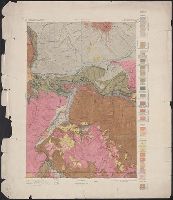
"Contour interval 200 feet."
Publisher:
Geological Survey,
Subject (Name):
Douglas, Edward Morehouse, 1855-1932, Gannett, Henry, 1846-1914, Hague, A. (Arnold), 1840-1917, Iddings, Joseph Paxson, 1857-1920, Leffingwell, W. H, Northern Transcontinental Survey, and Rensh
Subject (Topic):
Geology--Montana--Park County--Maps
Found in:
Beinecke Rare Book and Manuscript Library > Areal geology, Montana, Livingston sheet / U.S. Geological Survey, J.W. Powell, Director ; Henry Gannett, Chief Topographer ; A.H. Thompson, Geographer in charge ; triangulation by E.M. Douglas and J.H. Renshawe ; topography by Northern Transcontinental S
Creator:
Published / Created:
1917?]
Call Number:
38hc L337 1917
Container / Volume:
BRBL_00173
Image Count:
1
Resource Type:
Maps, Atlases & Globes
Description:
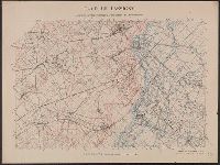
Shows "quadrille de Bonne en noir, quarillage Lambert en rouge." and WWI battle area NE of Lassigny, France.
Subject (Geographic):
Oise (France)--Maps
Subject (Topic):
World War, 1914-1918
Found in:
Beinecke Rare Book and Manuscript Library > Camp de Lassigny, Anciennes Organisations Francaises et Allemandes [cartographic material] / Engraved and printed by the U.S. Geological Survey.
Creator:
Published / Created:
1916?]
Call Number:
38hc L337 1916
Container / Volume:
BRBL_00173
Image Count:
1
Resource Type:
Maps, Atlases & Globes
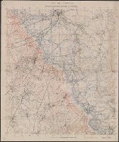
Description:
Shows "quadrille de Bonne en noir, quarillage Lambert en rouge." and WWI battle area NE of Lassigny, France.
Subject (Geographic):
Oise (France)--Maps
Subject (Topic):
World War, 1914-1918 and World War, 1914-1918--Campaigns--France
Found in:
Beinecke Rare Book and Manuscript Library > Camp de Lassigny, Anciennes Organisations Francaises et Allemandes [cartographic material].
Creator:
Published / Created:
1910
Call Number:
BrSides Double Folio 2019 84
Image Count:
1
Resource Type:
Maps, Atlases & Globes
Alternative Title:
Leadville special and Leadville special map
Description:
"Surveyed in 1879. Railroads and some shafts added later.", Relief shown by contours., and Shows mining activity.
Publisher:
U.S. Geological Survey,
Subject (Geographic):
Leadville (Colo.)--Maps.
Subject (Name):
Wilson, A. D.
Subject (Topic):
Mines and mineral resources--Colorado--Leadville--Maps.
Found in:
Beinecke Rare Book and Manuscript Library > Colorado (Lake County), Leadville special map [cartographic material] / triangulation and topography by A.D. Wilson, chief topographer.
Creator:
Published / Created:
1906
Call Number:
BrSides Folio 2019 61
Image Count:
1
Resource Type:
Maps, Atlases & Globes
Alternative Title:
Central City special map
Description:
"Surveyed in 1904.", Relief shown by contours and hachures., and Shows mining activity.
Publisher:
The Survey,
Subject (Geographic):
Central City (Colo.)--Maps. and Colorado--Central City
Subject (Name):
Chapman, Pearson, Douglas, E. M. (Edward Morehouse), 1855-1932, Moor, D. F., and Tweedy, Frank, 1854-1937
Subject (Topic):
Gold mines and mining--Colorado--Central City--Maps. and Mines and mineral resources--Colorado--Central City--Maps.
Found in:
Beinecke Rare Book and Manuscript Library > Colorado, Central City special map [cartographic material] / U.S. Geological Survey ; E.M. Douglas, geographer ; Frank Tweedy, in charge of section ; topography by Pearson Chapman and D.F. Moor ; triangulation by Frank Tweedy.
Creator:
Published / Created:
1916
Call Number:
304ed 1916
Container / Volume:
BRBL_00034A
Image Count:
1
Resource Type:
Maps, Atlases & Globes
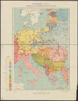
Alternative Title:
Central and South Eastern Europe.
Description:
"G.S., G.S., no. 2824."
Publisher:
Drawn and printed at the War Office,
Subject (Geographic):
Europe, Central--Maps
Found in:
Beinecke Rare Book and Manuscript Library > Ethnographical Map of Central & South Eastern Europe.
Creator:
Published / Created:
1905?]
Call Number:
837gce T764 1905
Container / Volume:
BRBL_00594
Image Count:
1
Resource Type:
Maps, Atlases & Globes
Description:
"Third annual report Reclamation Service, Pl. XXXI.", Relief shown by hachures and spot heights., and Shows irrigable lands, surveyed canal lines, and irrigation canals under construction.
Publisher:
U.S. G.P.O,
Subject (Name):
A. Hoen & Co and Geological Survey (U.S.). Reclamation Service. Annual report of the Reclamation Service
Subject (Topic):
Irrigation projects--Carson River Watershed (Nev.)--Maps, Irrigation projects--Truckee River Watershed (Calif. and Nev.)--Maps, and Irrigation--Nevada--Maps
Found in:
Beinecke Rare Book and Manuscript Library > General map of Truckee-Carson Project, Nevada / U.S. Geological Survey.
Branch:v1.61.8 ,Deployed:2024-06-20T11:14:55-04:00