Search
You Searched For
Search Results
- Creator:
- Geological Survey (U.S.)
- Published / Created:
- 1909
- Call Number:
- 844fcm Y83 1909
- Container / Volume:
- BRBL_00615
- Image Count:
- 1
- Resource Type:
- Maps, Atlases & Globes
- Found in:
- Beinecke Rare Book and Manuscript Library > Map of Yosemite Valley, Mariposa County, California / U.S. Geological Survey, George Otis Smith, Director ; E.M. Douglas, geographer ; State of California, George C. Pardee, Govenor.
- Creator:
- Geological Survey (U.S.)
- Published / Created:
- [1918]
- Call Number:
- 844fcm Y83 1918
- Container / Volume:
- BRBL_00615
- Image Count:
- 1
- Resource Type:
- Maps, Atlases & Globes
- Found in:
- Beinecke Rare Book and Manuscript Library > Map of Yosemite Valley, Yosemite National Park, California, Mariposa County / U.S. Geological Survey ; State of California ; E.M. Douglas, geographer ; R.B. Marshall, in charge of section ; topography by F.E. Matthes ; triangulation by C.F. Urquhart.
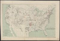
- Creator:
- Geological Survey (U.S.)
- Published / Created:
- 1913
- Call Number:
- 75ed 1913
- Container / Volume:
- BRBL_00410
- Image Count:
- 1
- Resource Type:
- Maps, Atlases & Globes
- Found in:
- Beinecke Rare Book and Manuscript Library > Map showing Indian Reservations within the Limits of the United States, 1913 / engraved and printed by the U.S. Geological Survey.
- Creator:
- Geological Survey (U.S.)
- Published / Created:
- [1897]
- Call Number:
- 75BF 1897
- Container / Volume:
- BRBL_00407A
- Image Count:
- 1
- Resource Type:
- Maps, Atlases & Globes
- Found in:
- Beinecke Rare Book and Manuscript Library > Map showing condition and progress of astronomic location, primary triangulation, primary traverse and precise leveling, for the fiscal year 1896-7.
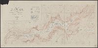
- Creator:
- Geological Survey (U.S.)
- Published / Created:
- [1897]
- Call Number:
- 75BH 1897
- Container / Volume:
- BRBL_00407A
- Image Count:
- 1
- Resource Type:
- Maps, Atlases & Globes
- Found in:
- Beinecke Rare Book and Manuscript Library > Map showing condition and progress of topographic surveys and location of gaging stations for the fiscal year 1896-1897.
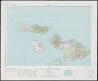
- Creator:
- Geological Survey (U.S.)
United States. Army Map Service
- Published / Created:
- 1974
- Call Number:
- 234 1974
- Container / Volume:
- BRBL_00020
- Image Count:
- 1
- Resource Type:
- Maps, Atlases & Globes
- Found in:
- Beinecke Rare Book and Manuscript Library > Maui, Hawaii. / prepared by the Army Map Service (AMLD).
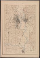
- Creator:
- Geological Survey (U.S.)
- Published / Created:
- 1898]
- Call Number:
- 824cbf Om1 1898
- Container / Volume:
- BRBL_00571
- Image Count:
- 1
- Resource Type:
- Maps, Atlases & Globes
- Found in:
- Beinecke Rare Book and Manuscript Library > Omaha and vicinity / U.S. Geological Survey ; Charles D. Walcott, director ; Henry Gannett, chief topographer ; Jno. H. Renshawe, topographer in charge ; control by Geo. T. Hawkins ; Mo. river from surveys by Mo. Riv. Com. ; topography by H.S. Wallace.
- Creator:
- Geological Survey (U.S.)
- Published / Created:
- [1900]
- Call Number:
- 846gc C786 1896
- Container / Volume:
- BRBL_00623
- Image Count:
- 1
- Resource Type:
- Maps, Atlases & Globes
- Found in:
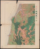
- Beinecke Rare Book and Manuscript Library > Oregon, Coos Bay quadrangle : land classification and density of standing timber / U.S. Geological Survey ; R.U. Goode, geographer in charge ; triangulation by W.T. Griswold ; topography by E.C. Barnard ; Henry Gannett, geographer in charge ; land classif
- Creator:
- Geological Survey (U.S.)
- Published / Created:
- [1900].
- Call Number:
- 846gc P838 1898
- Container / Volume:
- BRBL_00623
- Image Count:
- 1
- Resource Type:
- Maps, Atlases & Globes
- Found in:
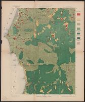
- Beinecke Rare Book and Manuscript Library > Oregon, Port Orford quadrangle : land classification and density of standing timber / U.S. Geological Survey ; R.U. Goode, geographer in charge ; triangulation by W.T. Griswold ; topography by A.E. Murlin ; Henry Gannett, geographer in charge ; land class
- Creator:
- Geological Survey (U.S.)
- Published / Created:
- [1900].
- Call Number:
- 846gc R72 1895
- Container / Volume:
- BRBL_00623
- Image Count:
- 1
- Resource Type:
- Maps, Atlases & Globes
- Found in:
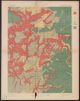
- Beinecke Rare Book and Manuscript Library > Oregon, Roseburg quadrangle : land classification and density of standing timber / U.S. Geological Survey ; Henry Gannett, chief topographer ; R.U. Goode, geographer in charge ; triangulation by W.T. Griswold ; topography by E.C. Barnard ; Henry Gannett,