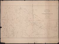
Geological and Geographical Survey of the Territories (U.S.)
Published / Created:
1879
Call Number:
80cbj 1879
Container / Volume:
BRBL_00537
Image Count:
1
Resource Type:
Maps, Atlases & Globes
Description:
Relief shown by hachures and spot heights.
Publisher:
the Survey,
Subject (Geographic):
Green River Watershed (Wyo.-Utah)--Maps
Subject (Name):
Bechler, G. R, Chittenden, George B, Clark, Fred A, Gannett, Henry, 1846-1914, Hayden, F. V. (Ferdinand Vandeveer), 1829-1887, Julius Bien & Co, and Wilson, A. D. (Allen D.)
Subject (Topic):
Watersheds--Idaho--Maps, Watersheds--Utah--Maps, and Watersheds--Wyoming--Maps
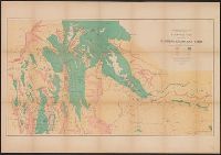
Geological and Geographical Survey of the Territories (U.S.)
Published / Created:
[1879]
Call Number:
833g 1879
Container / Volume:
BRBL_00586
Image Count:
1
Resource Type:
Maps, Atlases & Globes
Description:
"April 1879.", Includes notes., Relief shown by spot heights., Shows forests, vegetation, rock and coal, and arable lands., and To accompany the Survey's 13th (?) annual report.
Publisher:
Julius Bien, Lith., and The Survey ;
Subject (Name):
Hayden, F. V. (Ferdinand Vandeveer), 1829-1887
Subject (Topic):
Land capability for agriculture--Idaho--Maps, Land capability for agriculture--Utah--Maps, Land capability for agriculture--Wyoming--Maps, Natural resources--Idaho--Maps, and Natural resources--Utah--Maps
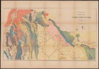
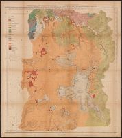
Geological and Geographical Survey of the Territories (U.S.)
Published / Created:
[1878?]
Call Number:
833ca 1878C
Container / Volume:
BRBL_00585
Image Count:
1
Resource Type:
Maps, Atlases & Globes
Description:
Relief shown by spot heights. and To accompany the Survey's 12th annual report (1878).
Publisher:
Julius Bien, Lith., and The Survey] ;
Subject (Name):
Endlich, F. M. (Frederick Miller), 1851-1899, Hayden, F. V. (Ferdinand Vandeveer), 1829-1887, Peale, A. C. (Albert Charles), 1849-1914, and St. John, O. H. (Orestes Henry)
Subject (Topic):
Geology--Idaho--Maps, Geology--Utah--Maps, and Geology--Wyoming--Maps
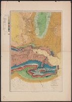
Geological and Geographical Survey of the Territories (U.S.)
Published / Created:
1876?]
Call Number:
836ca G825 1873
Container / Volume:
BRBL_00593
Image Count:
1
Resource Type:
Maps, Atlases & Globes
Description:
"Vertical distance between contour lines 250 feet.", Appears in Powell's Atlas accompanying the report on the geology of a portion of the Uinta Mountains and a region of country adjacent thereto. New York: Julius Bien, lith., l876., In top margin: Map B., and Relief shown by contours.
Publisher:
Julius Bien, lith.?,
Subject (Geographic):
Green River (Wyo.-Utah)--Maps
Subject (Name):
Bishop, F. M, De Motte, H. C, Graves, W. H, Kübel, S. J, Powell, John Wesley, 1834-1902, and Powell, John Wesley, 1834-1902. Atlas accompanying the report on the geology of a portion of the Uinta Mountai
Geological and Geographical Survey of the Territories (U.S.)
Published / Created:
1876?]
Call Number:
836g G825 1873
Container / Volume:
BRBL_00593
Image Count:
1
Resource Type:
Maps, Atlases & Globes
Description:
"Vertical distance between contour lines 250 feet.", Appears in Powell's Atlas accompanying the report on the geology of a portion of the Uinta Mountains and a region of country adjacent thereto. New York: Julius Bien, lith., l876., In top margin: Map A., and Relief shown by contours.
Publisher:
Julius Bien, lith.?,
Subject (Geographic):
Green River (Wyo.-Utah)--Maps
Subject (Name):
Bishop, F. M, De Motte, H. C, Graves, W. H, Kübel, S. J, Powell, John Wesley, 1834-1902, and Powell, John Wesley, 1834-1902. Atlas accompanying the report on the geology of a portion of the Uinta Mountai
Subject (Topic):
Copper ores--Green River Watershed (Wyo.-Utah)--Maps, Forests and forestry--Green River Watershed (Wyo.-Utah)--Maps, Irrigation--Green River Watershed (Wyo.-Utah)--Maps, and Silver ores--Green River Watershed (Wyo.-Utah)--Maps
Geological and Geographical Survey of the Territories (U.S.)
Published / Created:
1878]
Call Number:
833ca 1878B
Container / Volume:
BRBL_00585
Image Count:
1
Resource Type:
Maps, Atlases & Globes
Description:
"57"--Lower right margin., "Surveyed in 1877.", Relief shown by contours and spot heights., Shows geologic formations., and To accompany the Survey's 12th annual report (1878).
Publisher:
The Survey,
Subject (Geographic):
Wyoming--Maps, Topographic
Subject (Name):
Chittenden, George B, Endlich, F. M. (Frederick Miller), 1851-1899, and Hayden, F. V. (Ferdinand Vandeveer), 1829-1887
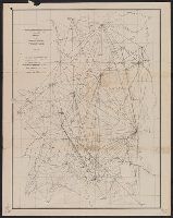
Geological and Geographical Survey of the Territories (U.S.)
Published / Created:
[1877]
Call Number:
833ca 1878AB
Container / Volume:
BRBL_00585
Image Count:
1
Resource Type:
Maps, Atlases & Globes
Description:
"56" printed in bottom right margin., Backed with linen. Stamp at top "10" crossed out with manuscript "No. 5" below., Relief shown by contours and spot heights., and Shows roads, springs, settlements, etc.
Publisher:
[The Survey],
Subject (Geographic):
Idaho--Maps, Utah--Maps, and Wyoming--Maps
Subject (Name):
Bien, Julius, 1829-1909, Gannett, Henry, 1846-1914, and Hayden, F. V. (Ferdinand Vandeveer), 1829-1887
Geological and Geographical Survey of the Territories (U.S.)
Published / Created:
[1878]
Call Number:
833ca Y38 1878
Container / Volume:
BRBL_00585
Image Count:
1
Resource Type:
Maps, Atlases & Globes
Description:
"Surveyed in 1878.", Includes notes., Relief shown by contours and spot heights. Depths shown by soundings., and To accompany the Survey's 12th annual report (1878).
Publisher:
Julius Bien, Lith., and The Survey ;
Subject (Geographic):
Yellowstone National Park--Maps, Topographic
Subject (Name):
Gannett, Henry, 1846-1914, Hayden, F. V. (Ferdinand Vandeveer), 1829-1887, Holmes, William Henry, 1846-1933, and Wilson, A. D. (Allen D.)
Geological and Geographical Survey of the Territories (U.S.)
Published / Created:
1873?]
Call Number:
834bf 1873A
Container / Volume:
BRBL_00590
Image Count:
1
Resource Type:
Maps, Atlases & Globes
Description:
Relief shown by spot heights.
Publisher:
U.S. Geological and Geographical Survey of the Territories?,
Subject (Name):
Bechler, G. R, Gannett, Henry, 1846-1914, Gardiner, James T. (James Terry), 1842-1912, Hayden, F. V. (Ferdinand Vandeveer), 1829-1887, and Wilson, A. D. (Allen D.)