
Search

Limit your search
- Maps✖[remove]6
- Geological and Geographical Survey of the Territories (U.S.)✖[remove]6
- Copper ores--Green River Watershed (Wyo.-Utah)--Maps1
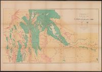
- Forests and forestry--Green River Watershed (Wyo.-Utah)--Maps1
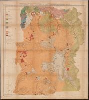
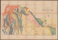
- Geology--Green River Watershed (Wyo.-Utah)--Maps1
- Geology--Idaho--Maps1
- Geology--Utah--Maps1
- Geology--Wyoming--Maps1
- Geology--Yellowstone National Park--Maps1
- Irrigation--Green River Watershed (Wyo.-Utah)--Maps1
- Land capability for agriculture--Idaho--Maps1
- Land capability for agriculture--Utah--Maps1
- Hayden, F. V. (Ferdinand Vandeveer), 1829-18874
- Bishop, F. M2
- De Motte, H. C2
- Gannett, Henry, 1846-19142
- Graves, W. H2
- Kübel, S. J2
- Powell, John Wesley, 1834-19022
- Powell, John Wesley, 1834-1902. Atlas accompanying the report on the geology of a portion of the Uinta Mountai2
- Wilson, A. D. (Allen D.)2
- Bechler, G. R1
Current results range from 1873 to 1879