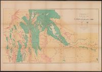
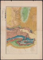
Geological and Geographical Survey of the Territories (U.S.)
Published / Created:
[1879]
Call Number:
833g 1879
Container / Volume:
BRBL_00586
Image Count:
1
Resource Type:
Maps, Atlases & Globes
Description:
"April 1879.", Includes notes., Relief shown by spot heights., Shows forests, vegetation, rock and coal, and arable lands., and To accompany the Survey's 13th (?) annual report.
Publisher:
Julius Bien, Lith., and The Survey ;
Subject (Name):
Hayden, F. V. (Ferdinand Vandeveer), 1829-1887
Subject (Topic):
Land capability for agriculture--Idaho--Maps, Land capability for agriculture--Utah--Maps, Land capability for agriculture--Wyoming--Maps, Natural resources--Idaho--Maps, and Natural resources--Utah--Maps
Geological and Geographical Survey of the Territories (U.S.)
Published / Created:
[1878]
Call Number:
833ca Y38 1878
Container / Volume:
BRBL_00585
Image Count:
1
Resource Type:
Maps, Atlases & Globes
Description:
"Surveyed in 1878.", Includes notes., Relief shown by contours and spot heights. Depths shown by soundings., and To accompany the Survey's 12th annual report (1878).
Publisher:
Julius Bien, Lith., and The Survey ;
Subject (Geographic):
Yellowstone National Park--Maps, Topographic
Subject (Name):
Gannett, Henry, 1846-1914, Hayden, F. V. (Ferdinand Vandeveer), 1829-1887, Holmes, William Henry, 1846-1933, and Wilson, A. D. (Allen D.)
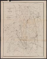
Geological and Geographical Survey of the Territories (U.S.)
Published / Created:
1873?]
Call Number:
834bf 1873A
Container / Volume:
BRBL_00590
Image Count:
1
Resource Type:
Maps, Atlases & Globes
Description:
Relief shown by spot heights.
Publisher:
U.S. Geological and Geographical Survey of the Territories?,
Subject (Name):
Bechler, G. R, Gannett, Henry, 1846-1914, Gardiner, James T. (James Terry), 1842-1912, Hayden, F. V. (Ferdinand Vandeveer), 1829-1887, and Wilson, A. D. (Allen D.)
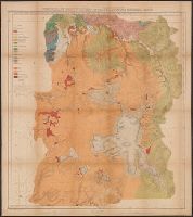
Geological and Geographical Survey of the Territories (U.S.)
Published / Created:
[1878?]
Call Number:
833ca 1878C
Container / Volume:
BRBL_00585
Image Count:
1
Resource Type:
Maps, Atlases & Globes
Description:
Relief shown by spot heights. and To accompany the Survey's 12th annual report (1878).
Publisher:
Julius Bien, Lith., and The Survey] ;
Subject (Name):
Endlich, F. M. (Frederick Miller), 1851-1899, Hayden, F. V. (Ferdinand Vandeveer), 1829-1887, Peale, A. C. (Albert Charles), 1849-1914, and St. John, O. H. (Orestes Henry)
Subject (Topic):
Geology--Idaho--Maps, Geology--Utah--Maps, and Geology--Wyoming--Maps
Geological and Geographical Survey of the Territories (U.S.)
Published / Created:
1876?]
Call Number:
836ca G825 1873
Container / Volume:
BRBL_00593
Image Count:
1
Resource Type:
Maps, Atlases & Globes
Description:
"Vertical distance between contour lines 250 feet.", Appears in Powell's Atlas accompanying the report on the geology of a portion of the Uinta Mountains and a region of country adjacent thereto. New York: Julius Bien, lith., l876., In top margin: Map B., and Relief shown by contours.
Publisher:
Julius Bien, lith.?,
Subject (Geographic):
Green River (Wyo.-Utah)--Maps
Subject (Name):
Bishop, F. M, De Motte, H. C, Graves, W. H, Kübel, S. J, Powell, John Wesley, 1834-1902, and Powell, John Wesley, 1834-1902. Atlas accompanying the report on the geology of a portion of the Uinta Mountai
Geological and Geographical Survey of the Territories (U.S.)
Published / Created:
1876?]
Call Number:
836g G825 1873
Container / Volume:
BRBL_00593
Image Count:
1
Resource Type:
Maps, Atlases & Globes
Description:
"Vertical distance between contour lines 250 feet.", Appears in Powell's Atlas accompanying the report on the geology of a portion of the Uinta Mountains and a region of country adjacent thereto. New York: Julius Bien, lith., l876., In top margin: Map A., and Relief shown by contours.
Publisher:
Julius Bien, lith.?,
Subject (Geographic):
Green River (Wyo.-Utah)--Maps
Subject (Name):
Bishop, F. M, De Motte, H. C, Graves, W. H, Kübel, S. J, Powell, John Wesley, 1834-1902, and Powell, John Wesley, 1834-1902. Atlas accompanying the report on the geology of a portion of the Uinta Mountai
Subject (Topic):
Copper ores--Green River Watershed (Wyo.-Utah)--Maps, Forests and forestry--Green River Watershed (Wyo.-Utah)--Maps, Irrigation--Green River Watershed (Wyo.-Utah)--Maps, and Silver ores--Green River Watershed (Wyo.-Utah)--Maps