Skip to search
Skip to main content
Skip to first result
Search
You Searched For
Extent of Digitization
Completely digitized
Repository
Beinecke Rare Book and Manuscript Library
Creator
Goos, Pieter, approximately 1616-1675
Search Results
Creator:
Published / Created:
1669?]
Call Number:
183 1669
Container / Volume:
BRBL_00682
Image Count:
1
Resource Type:
Maps, Atlases & Globes
Alternative Title:
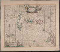
Pascaerte van Groen-landt, Yslandt, Straet Davis
Description:
Appears in the author's Zee-atlas ofte water-waereld. [Amsterdam : Pieter Goos], 1666.
Publisher:
Pieter Goos,
Subject (Geographic):
North Atlantic Ocean--Maps--Early works to 1800
Subject (Name):
Goos, Pieter, approximately 1616-1675. Zee-atlas ofte water-waereld
Subject (Topic):
Nautical charts--North Atlantic Ocean--Early works to 1800
Found in:
Beinecke Rare Book and Manuscript Library > Pascaerte van Groen-landt, Yslandt, Straet Davids [sic] en Ian Mayen Eylandt : hoemen de selvige van Hitlandt en de noort custen van Schotlandt en Yrlandt beseylen mach.
Creator:
Published / Created:
anno 1666.
Call Number:
23cea 1666
Container / Volume:
BRBL_00682
Image Count:
1
Resource Type:
Maps, Atlases & Globes
Alternative Title:
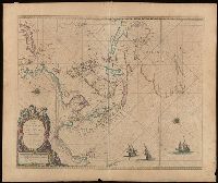
Pascaerte vande Zvyd-Zee tussche California, en Ilhas de Ladrones
Description:
Chart of the Pacific Ocean showing the coastlines of Tasmania, Carpentaria, New Guinea, Japan, California, and Pacific Islands.
Publisher:
By Pieter Goos, op't Waater inde Vergulde Zeespiegel,
Subject (Geographic):
Pacific Ocean--Maps--Early works to 1800
Subject (Name):
Goos, Pieter, approximately 1616-1675. Zee-atlas ofte water-wereld
Found in:
Beinecke Rare Book and Manuscript Library > Pascaerte vande Zuyd-Zee tussche California, en Ilhas de Ladrones [cartographic material] / by Pieter Goos, op't Waater inde Vergulde Zeespiegel.
Creator:
Call Number:
Lanman 27 1666
Image Count:
1
Resource Type:
Maps, Atlases & Globes
Abstract:
Sea chart of Australia (Hollandia Nova) Southeast Asia, China, Japan, Korea and India. Three Dutch galleons appear in the lower right corner of the map.
Description:
Bar scales in Dutch, Spanish and English miles.
Subject (Geographic):
Asia--Maps--Early works to 1800., Australia--Maps--Early works to 1800., and Southeast Asia--Maps--Early works to 1800.
Found in:
Beinecke Rare Book and Manuscript Library > Paskaerte zynde t'Oosterdeel van Oost Indien : met alle de Eylanden daer ontrendt geleegen van C. Comorin tot aen Iapan / by Pieter Goos, op't Waeter in de Vergulde Zeespiegel.
Branch:v1.68.6 ,Deployed:2025-07-02T08:09:49-04:00