Skip to search
Skip to main content
Skip to first result
Search
You Searched For
Extent of Digitization
Completely digitized
Creator
Goos, Pieter, approximately 1616-1675
Search Results
Creator:
Published / Created:
1669?]
Call Number:
183 1669
Container / Volume:
BRBL_00682
Image Count:
1
Resource Type:
Maps, Atlases & Globes
Alternative Title:
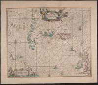
Pascaerte van Groen-landt, Yslandt, Straet Davis
Description:
Appears in the author's Zee-atlas ofte water-waereld. [Amsterdam : Pieter Goos], 1666.
Publisher:
Pieter Goos,
Subject (Geographic):
North Atlantic Ocean--Maps--Early works to 1800
Subject (Name):
Goos, Pieter, approximately 1616-1675. Zee-atlas ofte water-waereld
Subject (Topic):
Nautical charts--North Atlantic Ocean--Early works to 1800
Found in:
Beinecke Rare Book and Manuscript Library > Pascaerte van Groen-landt, Yslandt, Straet Davids [sic] en Ian Mayen Eylandt : hoemen de selvige van Hitlandt en de noort custen van Schotlandt en Yrlandt beseylen mach.
Creator:
Published / Created:
anno 1666.
Call Number:
23cea 1666
Container / Volume:
BRBL_00682
Image Count:
1
Resource Type:
Maps, Atlases & Globes
Alternative Title:
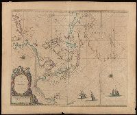
Pascaerte vande Zvyd-Zee tussche California, en Ilhas de Ladrones
Description:
Chart of the Pacific Ocean showing the coastlines of Tasmania, Carpentaria, New Guinea, Japan, California, and Pacific Islands.
Publisher:
By Pieter Goos, op't Waater inde Vergulde Zeespiegel,
Subject (Geographic):
Pacific Ocean--Maps--Early works to 1800
Subject (Name):
Goos, Pieter, approximately 1616-1675. Zee-atlas ofte water-wereld
Found in:
Beinecke Rare Book and Manuscript Library > Pascaerte vande Zuyd-Zee tussche California, en Ilhas de Ladrones [cartographic material] / by Pieter Goos, op't Waater inde Vergulde Zeespiegel.
Creator:
Call Number:
Lanman 27 1666
Image Count:
1
Resource Type:
Maps, Atlases & Globes
Abstract:
Sea chart of Australia (Hollandia Nova) Southeast Asia, China, Japan, Korea and India. Three Dutch galleons appear in the lower right corner of the map.
Description:
Bar scales in Dutch, Spanish and English miles.
Subject (Geographic):
Asia--Maps--Early works to 1800., Australia--Maps--Early works to 1800., and Southeast Asia--Maps--Early works to 1800.
Found in:
Beinecke Rare Book and Manuscript Library > Paskaerte zynde t'Oosterdeel van Oost Indien : met alle de Eylanden daer ontrendt geleegen van C. Comorin tot aen Iapan / by Pieter Goos, op't Waeter in de Vergulde Zeespiegel.
Branch:v1.68.6 ,Deployed:2025-07-02T08:09:52-04:00