Skip to search
Skip to main content
Skip to first result
Search
You Searched For
Access
Public
Resource Type
Maps, Atlases & Globes
Creator
Great Britain. MI9
New Search
Search Results
Creator:
Published / Created:
1942?]
Call Number:
66 1942
Container / Volume:
BRBL_00347
Image Count:
4
Resource Type:
Maps, Atlases & Globes
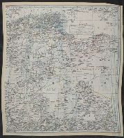
Description:
Have hemmed edges., Includes index to boundaries and index to adjoining sheets., Publisher's designations: K1/K2 - K3/K4., Relief shown by hachures and spot heights., and World War II maps printed on parachute silk.
Publisher:
MI9,
Subject (Geographic):
Africa, North--Maps and Africa, West--Maps
Subject (Topic):
Military maps
Found in:
Beinecke Rare Book and Manuscript Library > North Africa containing Morocco, Algeria, Tunisia, Italian Libya, and Spanish Rio de Oro.
Creator:
Published / Created:
1944?]
Call Number:
625 1941
Container / Volume:
BRBL_00333
Image Count:
2
Resource Type:
Maps, Atlases & Globes
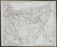
Alternative Title:
Kenya Colony & Juba River. and Kenya Colony and Juba River.
Description:
Cloth map., Publisher's designations: P -- Q., and Relief shown by spot heights.
Publisher:
MI9,
Subject (Geographic):
Juba River Valley (Ethiopia and Somalia)--Maps, Kenya--Maps, and Somalia--Maps
Subject (Topic):
Maps, Military
Found in:
Beinecke Rare Book and Manuscript Library > Somaliland ; Kenya Colony & Juba River.
Branch:v1.64.0 ,Deployed:2024-09-11T10:25:40-04:00