Skip to search
Skip to main content
Skip to first result
Search
You Searched For
Extent of Digitization
Completely digitized
Creator
Great Britain. Ordnance Survey
Search Results
Creator:
Published / Created:
1913
Call Number:
634 P37 1913
Container / Volume:
BRBL_00336
Image Count:
2
Resource Type:
Maps, Atlases & Globes
Alternative Title:
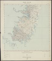
Great Britain. War Office. General Staff. Geographical Section. [G.S.G.S.], GSGS (Series) ; 2639., Pemba Island, Pemba Island. Chake Chake [cartographic material]., Pemba Island. Sheet 1 [cartographic material]., and Pemba Island. Sheet 2 [cartographic material].
Description:
Includes index to adjoining sheet.
Publisher:
Ordnance Survey Office,
Subject (Geographic):
Pemba Island (Tanzania)--Maps
Subject (Name):
Great Britain. War Office. General Staff. Geographical Section
Found in:
Beinecke Rare Book and Manuscript Library > Africa 1:63 360. Pemba Island [cartographic material] / drawn and printed at the Ordnance Survey Office, Southampton, 1913.
Creator:
Published / Created:
1908
Call Number:
354 1906
Container / Volume:
BRBL_00112
Image Count:
1
Resource Type:
Maps, Atlases & Globes
Alternative Title:
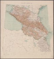
G.S.G.S. ; no. 2167 and GSGS (Series) ; 2167.
Publisher:
War Office],
Subject (Geographic):
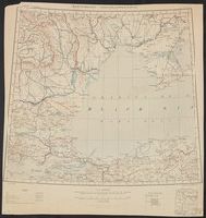
Caucasus--Maps
Subject (Name):
Great Britain. War Office. General Staff. Geographical Survey
Found in:
Beinecke Rare Book and Manuscript Library > Caucasia.
Creator:
Published / Created:
1940
Call Number:
32eb 1940
Container / Volume:
BRBL_00075
Image Count:
1
Resource Type:
Maps, Atlases & Globes
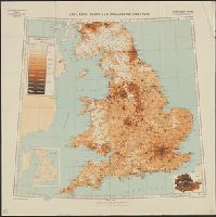
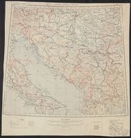
Description:
Based on Ordnance Survey map of 1934, from 1931 census.
Publisher:
Generalstab des Heeres, Abteilung für Kriegskarten- und Vermessungswesen (Mil.-Geo.),
Subject (Geographic):
England--Population--Maps
Subject (Topic):
Population density--England--Maps
Found in:
Beinecke Rare Book and Manuscript Library > England : Bevölkerungsverteilung 1931.
Creator:
Published / Created:
1919
Call Number:
11hcf 1919D-53
Image Count:
1
Resource Type:
Maps, Atlases & Globes
Alternative Title:
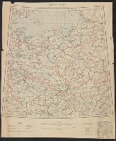
Berlin-Wien, G.S.G.S. ; 2918, and GSGS (Series) ; 2918.
Description:
"Note: Boundaries are shown as they existed before the War."
Publisher:
Ordnance Survey,
Subject (Geographic):
Europe--Maps
Found in:
Beinecke Rare Book and Manuscript Library > Europe 1:2,000,000 : Berlin-Wien, M.N. 33. 34.
Creator:
Published / Created:
1919
Call Number:
11hcf 1919D-54
Image Count:
1
Resource Type:
Maps, Atlases & Globes
Alternative Title:
Bucuresti-Constantinople, G.S.G.S. ; 2918, and GSGS (Series) ; 2918.
Description:
"Note: Boundaries are shown as they existed before the War."
Publisher:
Ordnance Survey,
Subject (Geographic):
Europe--Maps
Found in:
Beinecke Rare Book and Manuscript Library > Europe 1:2,000,000 : Bucuresti-Constantinople, K.I. 35. 36.
Creator:
Published / Created:
1919
Call Number:
11hcf 1919D-55
Image Count:
1
Resource Type:
Maps, Atlases & Globes
Alternative Title:
Buda Pest - Rome, G.S.G.S. ; 2918, and GSGS (Series) ; 2918.
Description:
"Note: Boundaries are shown as they existed before the War."
Publisher:
Ordnance Survey,
Subject (Geographic):
Europe--Maps
Found in:
Beinecke Rare Book and Manuscript Library > Europe 1:2,000,000 : Buda Pest - Rome, K.I. 33. 34.
Creator:
Published / Created:
1919
Call Number:
11hcf 1919D-56
Image Count:
1
Resource Type:
Maps, Atlases & Globes
Alternative Title:
G.S.G.S. ; 2918, GSGS (Series) ; 2918., and Petrograd
Description:
"Note: Boundaries are shown as they existed before the War."
Publisher:
Ordnance Survey,
Subject (Geographic):
Europe--Maps
Found in:
Beinecke Rare Book and Manuscript Library > Europe 1:2,000,000 : Petrograd, G.P. 35. 36.
Creator:
Published / Created:
1919
Call Number:
11hcf 1919D-57
Image Count:
1
Resource Type:
Maps, Atlases & Globes
Alternative Title:
G.S.G.S. ; 2918, GSGS (Series) ; 2918., and Vilna - Kiev
Description:
"Note: Boundaries are shown as they existed before the War."
Publisher:
Ordnance Survey,
Subject (Geographic):
Europe--Maps
Found in:
Beinecke Rare Book and Manuscript Library > Europe 1:2,000,000 : Vilna - Kiev, M.N. 35. 36.
Creator:
Published / Created:
192-.
Call Number:
11hcf 1919D-58
Image Count:
1
Resource Type:
Maps, Atlases & Globes
Alternative Title:
Combined map of Istambul and Izmir and part of Sinob and Konia sheets, Europe 1:1,000,000, G.S.G.S. ; 2555, GSGS (Series) ; 2555., International Map Europe 1:1,000,000, and Map No. 2
Description:
"Geographic Section, Peace Congress 103."
Publisher:
Ordnance Survey,
Subject (Geographic):
Europe--Maps
Found in:
Beinecke Rare Book and Manuscript Library > International Map Europe 1:1,000,000 : Map No. 2, Combined map of Istambul and Izmir and part of Sinob and Konia sheets.
Creator:
Published / Created:
1901
Call Number:
217 1899B
Image Count:
6
Resource Type:
Maps, Atlases & Globes
Description:
Includes index map.
Publisher:
The Office,
Subject (Geographic):
Bermuda Islands--Maps.
Subject (Name):
Savage, A. J
Found in:
Beinecke Rare Book and Manuscript Library > Islands of Bermuda [cartographic material] / surveyed and contoured in 1898-9 by Lieut. A.J. Savage, R.E. ; heliozincographed and published at the Ordnance Survey Office.
Branch:v1.68.6 ,Deployed:2025-07-02T08:09:31-04:00