
Search


Limit your search
- Completely digitized✖[remove]25
- Public25
- Great Britain. Ordnance Survey✖[remove]25
- Geological Survey of Great Britain2
- Germany. Heer. Abteilung für Kriegskarten- und Vermessungswesen. IV. Mil.-Geo1
- Chron.--1853-18742
- Railroads--China--Maps2
- Telegraph lines--China--Maps2
- Geology--Scotland--Stirlingshire--Maps1
- Geology--Scotland--West Lothian--Maps1
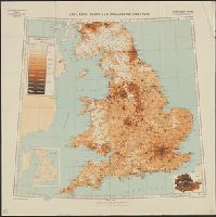
- Population density--England--Maps1
- Railroads--China--Manchuria--Maps1
- Telegraph lines--China--Manchuria--Maps1
- World War, 1914-1918--Trench warfare--France--Maps1
Current results range from 1843 to 1940