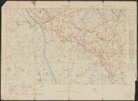
G.S, .G.S ; 3062, GSGS (Series) ; 3062., and St. Julien
Description:
"Ordnance Survey, July 1917.", "Trenches corrected to 30-6-17.", Glossary on verso., Includes index to adjoining sheets., and Relief shown by contours.
Publisher:
Ordnance Survey,
Subject (Geographic):
St. Julien (France)--Maps
Subject (Topic):
World War, 1914-1918--Trench warfare--France--Maps
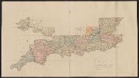
"Printed from an electrotype.", Copy 2: Sheets 7, 10-11, 15, 17-18, 20 and 21 only. Hand colored., For a detailed description of the maps, see: The first Ordnance Survey map : a history and cartobibliography of the one-inch Old Series of England and Wales / Roger Hellyer and Richard Oliver. London : The Charles Close Society, 2015., Some sheets issued as quarter sheets., Statement of responsibility and imprint based on sheet 1., and Topographic series of England and Wales with relief shown by hachures.
Publisher:
Published by Colonel Colby ...,
Subject (Geographic):
England--Maps, Great Britain--Surveys--Maps, Military topography--Great Britain, and Wales--Maps
"Printed from an electrotype.", Copy 1: Sheets 1-31 only. Accompanied by key sheet, "Index to the Ordnance Survey of Great Britain including the plate published.", For a detailed description of the maps, see: The first Ordnance Survey map : a history and cartobibliography of the one-inch Old Series of England and Wales / Roger Hellyer and Richard Oliver. London : The Charles Close Society, 2015., Some sheets issued as quarter sheets., Statement of responsibility and imprint based on sheet 1., and Topographic series of England and Wales with relief shown by hachures.
Publisher:
Published by Colonel Colby ...,
Subject (Geographic):
England--Maps, Great Britain--Surveys--Maps, Military topography--Great Britain, and Wales--Maps