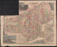
Forty miles around New York., H.H. Lloyd's new map of the great metropolis., H.H. Lloyd's New-York and forty miles around it., New map of the great metropolis., and New-York and forty miles around it.
Description:
Includes lists of maps published by the company (on map) and Relief shown by hachures.
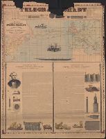
Incl. ill., 2 texts: [1.] Account of the invention and operation of the magnetic telegraph -- [2.] Description of making and laying submarine telegraph cables.
Publisher:
H.H. Lloyd & Co.,
Subject (Geographic):
Atlantic Ocean--Maps
Subject (Topic):
Cables, Submarine--Atlantic Ocean--Maps and Telegraph cables--Atlantic Ocean--Maps
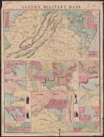
[Virginia, Maryland, Delaware] -- United States -- District of Columbia -- New Orleans, mouth of Mississippi -- Savannah -- Mobile Bay -- Galveston Bay -- Map of Mississippi River [2 maps] -- Cairo -- Pensacola Bay -- Norfolk Harbor -- Hampton Roads. and Reli
Publisher:
H.H. Lloyd : and Published under the auspices of the American Geographical and Statistical Society,
Subject (Geographic):
United States--Maps
Subject (Name):
American Geographical and Statistical Society, Haskins, Charles, and Viele, Egbert L. (Egbert Ludovicus), 1825-1902
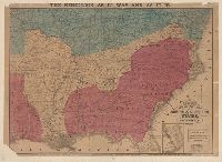
At top of map: The rebellion as it was, Indicates towns, railroads, rivers, names and boundaries of states, and relief by hachures., and Shows "territory held by Rebels June 1st, 1864, in red," "territory gained from Rebels since January 1st, 1862, in yellow."
Publisher:
H.H. Lloyd & Co.,
Subject (Geographic):
United States--History--Civil War, 1861-1865--Maps