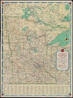
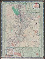
Minnesota official road map and Phillips Petroleum Company 1938 official road map, Minnesota
Description:
In lower left: 438-J.C. 11-L., Includes inset of Fort William area (scale [ca. 1:2,534,400]) and index., and Map of U.S. roads (indexed for national parks and monuments), local route maps of Minneapolis-St.Paul and Duluth, text, and ill. on verso.
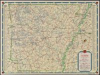
North Dakota, South Dakota, North Dakota, South Dakota, official road map, Phillips Petroleum Company 1938 official road map, North Dakota, South Dakota, and Phillips Petroleum Company official road map, United States.
Description:
"365-J C" and "L-1.", "Phillips Petroleum Company official road map, United States" (scale [ca. 1:10,137,600]), road map of "Black Hills region, South Dakota," 4 local route maps, text, and ill. on verso., Indexed., and Relief shown by hachures.
Publisher:
H.M. Gousha,
Subject (Geographic):
North Dakota--Maps and South Dakota--Maps
Subject (Name):
Phillips Petroleum Company
Subject (Topic):
Roads--North Dakota--Maps and Roads--South Dakota--Maps
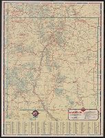
1938 road map, United States., New Mexico, New Mexico, Standard stations road map, Road map, New Mexico, Road map, United States., Standard stations road map, New Mexico, and United States.
Description:
Distance chart, ill., index to points of interest, text, 2 local route maps, and "1938 road map, United States" (scale [ca. 1:10,500,000]) on verso., In lower right: L-1., Indexed., and Relief shown by hachures and spot heights.
Publisher:
H.M. Gousha,
Subject (Geographic):
New Mexico--Maps
Subject (Name):
Standard Oil Company of Texas
Subject (Topic):
Express highways--United States--Maps and Roads--New Mexico--Maps
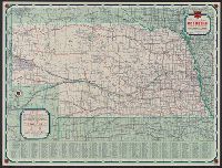
Nebraska, Nebraska official road map, and Phillips Petroleum Company 1939 official road map, Nebraska
Description:
"339 J.C. 10-M.", "Phillips Petroleum Company official road map, United States" (scale [ca. 1:10,137,600]), text, and col. ill. on verso., Indexed., and Relief shown by hachures and spot heights.
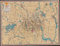
Shell metropolitan Minneapolis, St. Paul and Shell road map, metropolitan Minneapolis, St. Paul
Description:
In lower right: 12-M 1939-1 221-S.C. and Maps of downtown Minneapolis and St. Paul, index, text, and ill. on verso.
Publisher:
H.M. Goushá Co.,
Subject (Geographic):
Minneapolis Metropolitan Area (Minn.)--Maps and Saint Paul Metropolitan Area (Minn.)--Maps
Subject (Name):
Shell Union Oil Corporation
Subject (Topic):
Central business districts--Minnesota--Minneapolis--Maps, Central business districts--Minnesota--Saint Paul--Maps, Roads--Minnesota--Minneapolis Metropolitan Area--Maps, and Roads--Minnesota--Saint Paul Metropolitan Area--Maps
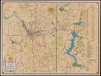
Downtown Spokane., Shell street guide and metropolitan map of Spokane and vicinity, Street guide and metropolitan map of Spokane and vicinity, and Street map of Spokane.
Description:
"469-S" and "10-M 1939-1.", Indexed "Street map of Spokane," "Downtown Spokane" map, text, and ill. on verso., Indexed., and Relief shown by hachures and spot heights.
Publisher:
H.M. Gousha,
Subject (Geographic):
Spokane (Wash.)--Maps and Spokane Metropolitan Area (Wash.)--Maps
Subject (Name):
Shell Union Oil Corporation
Subject (Topic):
Central business districts--Washington (State)--Spokane--Maps, Roads--Washington (State)--Spokane Metropolitan Area--Maps, and Streets--Washington (State)--Spokane--Maps
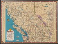
"1939-1", "Above data in effect as of January 1, 1939", Also shows northern Washington, northern Idaho, and northwestern Montana., At head of title: Shell., Directory of radio stations in British Columbia, Alberta, and the western United States on verso., and Inde