Skip to search
Skip to main content
Skip to first result
Search
You Searched For
Access
Public
Repository
Beinecke Rare Book and Manuscript Library
Format
cartographic
Genre
Maps
Creator
Homann, Johann Baptist, 1663-1724
New Search
Search Results
Creator:
Published / Created:
1720?]
Call Number:
33 1700
Container / Volume:
BRBL_00077
Image Count:
1
Resource Type:
Maps, Atlases & Globes
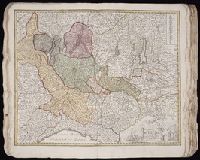
Description:
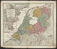
Imperfect: Split into 2 pieces. Mounted on board. Sheet measures 51.3 x 59.7 cm. and Three insets: 1) at top. Batavorum coloniae occidental indiis septentrionalis Americae implantatae. With view of New Amsterdam. 2) at left. India orientalis Batavoru
Publisher:
[Johann Baptist Homann,
Subject (Geographic):
Netherlands--Maps--Early works to 1800 and New York (State)--Maps
Found in:
Beinecke Rare Book and Manuscript Library > Belgii pars septentrionalis communi nomine vulgo Hollandia nuncupata continens statum potentissimae Batavorum Reipublicea sev provincias VII foederatas / exhibente Io. Baptista Homanno.
Creator:
Published / Created:
1720?]
Call Number:
331 1720
Container / Volume:
BRBL_00078
Image Count:
1
Resource Type:
Maps, Atlases & Globes
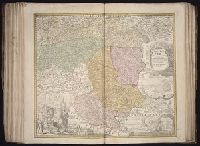
Description:
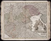
Sheet measures 53.4 x 61.4 cm. Ms. note on verso: No. 9, Holland. and Three insets: 1) at top. Batavorum coloniae occidental indiis septentrionalis Americae implantatae. With view of New Amsterdam. 2) at left. India orientalis Batavorum commerciis,
Publisher:
[Johann Baptist Homann,
Subject (Geographic):
Netherlands--Maps--Early works to 1800 and New York (State)--Maps
Found in:
Beinecke Rare Book and Manuscript Library > Belgii pars septentrionalis communi nomine vulgo Hollandia nuncupata continens statum potentissimae Batavorum Reipublicea sev provincias VII foederatas / exhibente Io. Baptista Homanno.
Creator:
Published / Created:
1743
Call Number:
1975 Folio 31
Collection Title:
[Atlas factice of 42 maps, produced by the Homann Erben firm]
Image Count:
1
Alternative Title:
Staat von der Republic Genova, nach seiner Eintheilung in die ost- u. west-Revier
Publisher:
Homann Erben
Subject (Geographic):
Genoa (Italy) --Maps --Early works to 1800
Subject (Topic):
Atlases, German --Early works to 1800
Collection Created:
[Nuremberg,
Found in:
Beinecke Rare Book and Manuscript Library > Carta Geographica, la quale rappresenta lo Stato della Republica di Genova partita nella Riviera di Levante et di Ponente / [cartographic material] / data in publico per gli Heredi d'Homann ; con privil. imp le 1743 = Staat von der Republic Genova, nach s
Creator:
Published / Created:
1715?
Call Number:
1973 Folio 30
Collection Title:
[Atlas factice of 32 maps and 1 distance table, produced by the Homann Erben firm]
Image Count:
2
Publisher:
[Johann Baptist Homann]
Subject (Geographic):
Saxony (Germany) --Maps --Early works to 1800
Subject (Topic):
Atlases, German --Early works to 1800
Collection Created:
[Nuremberg : s.n., 1701-1760]
Found in:
Beinecke Rare Book and Manuscript Library > Circulus Saxoniae inferioris in omnes suos status et principatus / [cartographic material] / accurate divisus ex conatibus Io. Bapt. Homanni
Creator:
Published / Created:
[before 1724?]
Call Number:
BrSides Double Folio 2019 42
Image Count:
1
Resource Type:
Maps, Atlases & Globes
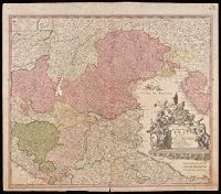
Description:
Bar scales given in "mill. Germanica," "mill. Gallica," and "mill. Italica.", Imperfect: torn along bottom fold, with no loss of text. Watermark. Manuscript number in right corner. From the Karpinski-von Wieser Map Collection., Includes illustration "Die Vestung Kofel.", Relief shown pictorially., and With privilege statement, "Cum privilegio Sac. Cas. Maj." at bottom of cartouche.
Publisher:
[Johann Baptist Homann],
Subject (Geographic):
Tyrol (Austria)--Maps--Early works to 1800.
Found in:
Beinecke Rare Book and Manuscript Library > Comitatus principalis Tirolis : in quo Episc. Tridentin[us] et Brixensis, Comitatus Brigantinus, Feldkirchiae Sonnebergae et Pludentii accuratè exhibentur / editore Ioh. Baptista Homanno, Sacrae Caes. Majestatis Geographo.
Creator:
Published / Created:
1720?
Call Number:
1975 Folio 31
Collection Title:
[Atlas factice of 42 maps, produced by the Homann Erben firm]
Image Count:
1
Publisher:
Johann Baptist Homann
Subject (Geographic):
Italy, Northern --Maps --Early works to 1800 and Veneto (Italy) --Maps --Early works to 1800
Subject (Topic):
Atlases, German --Early works to 1800
Collection Created:
[Nuremberg,
Found in:
Beinecke Rare Book and Manuscript Library > Dominii Veneti cum vicinis Parmae, Mutinae, Mantuae, et Mirandolae statibus nova descriptio / [cartographic material] / edita a Ioh. Baptista Homanno, sacrae caes. majestatis geographo
Creator:
Published / Created:
[1720?]
Call Number:
BrSides Double Folio 2019 22
Image Count:
1
Resource Type:
Maps, Atlases & Globes
Description:
"Cum privilegio Sac. Caes. Majestatis.", Bar scales given in "milliaria Germanica," "milliaria Gallica," and ""milliaria Italica.", Manuscript number in upper right corner: 43. From the Karpinski-von Wieser Map Collection., and Relief shown pictorially.
Publisher:
[Johann Baptist Homann]
Subject (Geographic):
Italy, Northern--Maps--Early works to 1800. and Veneto (Italy)--Maps--Early works to 1800.
Found in:
Beinecke Rare Book and Manuscript Library > Dominii Veneti cum vicinis Parmae, Mutinae, Mantuae, et Mirandolae statibus nova descriptio / edita a Ioh. Baptista Homanno, sacrae caes. majestatis geographo.
Creator:
Published / Created:
1730?
Call Number:
1975 Folio 31
Collection Title:
[Atlas factice of 42 maps, produced by the Homann Erben firm]
Image Count:
1
Publisher:
Homann
Subject (Geographic):
Milan (Italy : Province) --Maps --Early works to 1800
Subject (Topic):
Atlases, German --Early works to 1800
Collection Created:
[Nuremberg,
Found in:
Beinecke Rare Book and Manuscript Library > Ducatus Mediolani una cum confinyes accurata tabula / [cartographic material] / exhibitus auctus et eme[n]datus per Ioh. Bapt. Homannum
Creator:
Published / Created:
[ca. 1710]
Call Number:
1983 Folio 23
Collection Title:
[Atlas factice of 50 maps, primarily by Johann Baptist Homann and/or issued by the Homann Erben
Image Count:
1
Publisher:
[Johann Baptist Homann]
Subject (Geographic):
Graz (Austria) --Maps, Pictorial --Early works to 1800 and Styria (Austria) --Maps --Early works to 1800
Collection Created:
[Nuremberg : Homann Erben, 1710-1786]
Found in:
Beinecke Rare Book and Manuscript Library > Ducatus Stiriae novissima tabula [cartographic material] / ex ampliore mappa olim R. Dni. Georgii Matth. Vischer S.C.M., Leopoldi I. Glorssae. Memae. Geographi deducta ; et in hac utiliore forma curiosorum oculis exhibita a Ioh. Bapti. Homanno
Creator:
Published / Created:
1730
Call Number:
1975 Folio 31
Collection Title:
[Atlas factice of 42 maps, produced by the Homann Erben firm]
Image Count:
1
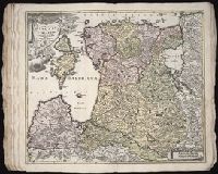
Alternative Title:
Ducatuum Livoniae et Curlandiae cum vicinis insulis
Publisher:
Johann Baptist Homann
Subject (Geographic):
Estonia --Maps --Early works to 1800 and Latvia --Maps --Early works to 1800
Subject (Topic):
Atlases, German --Early works to 1800
Collection Created:
[Nuremberg,
Found in:
Beinecke Rare Book and Manuscript Library > Ducatvvm Livoniae et Cvrlandiae cum vicinis insulis [cartographic material] : nova exhibitio geographica / editore Ioh. Baptista Homanno
Branch:v1.61.6 ,Deployed:2024-06-12T09:55:19-04:00