Search
You Searched For
Search Results
- Creator:
- Homann, Johann Baptist, 1663-1724
Vischer, Georg Matthaeus, 1628-1695
- Published / Created:
- [ca. 1710]
- Call Number:
- 1983 Folio 23
- Collection Title:
- [Atlas factice of 50 maps, primarily by Johann Baptist Homann and/or issued by the Homann Erben
- Image Count:
- 1
- Found in:
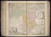
- Beinecke Rare Book and Manuscript Library > Ducatus Stiriae novissima tabula [cartographic material] / ex ampliore mappa olim R. Dni. Georgii Matth. Vischer S.C.M., Leopoldi I. Glorssae. Memae. Geographi deducta ; et in hac utiliore forma curiosorum oculis exhibita a Ioh. Bapti. Homanno
- Creator:
- Homann, Johann Baptist, 1663-1724
- Published / Created:
- 1730
- Call Number:
- 1975 Folio 31
- Collection Title:
- [Atlas factice of 42 maps, produced by the Homann Erben firm]
- Image Count:
- 1
- Found in:
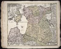
- Beinecke Rare Book and Manuscript Library > Ducatvvm Livoniae et Cvrlandiae cum vicinis insulis [cartographic material] : nova exhibitio geographica / editore Ioh. Baptista Homanno
- Creator:
- Homann, Johann Baptist, 1663-1724
- Published / Created:
- 1720?
- Call Number:
- 1975 Folio 31
- Collection Title:
- [Atlas factice of 42 maps, produced by the Homann Erben firm]
- Image Count:
- 1
- Found in:
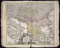
- Beinecke Rare Book and Manuscript Library > Fluviorum in Europa principis Danubii [cartographic material] : cum adiacentibus regnis nec non totius Graeciae et archipelagi novissima tabula / authore Joh. Baptista Homanno
- Creator:
- Homann, Johann Baptist, 1663-1724
- Published / Created:
- 1720?
- Call Number:
- 1973 Folio 30
- Collection Title:
- [Atlas factice of 32 maps and 1 distance table, produced by the Homann Erben firm]
- Image Count:
- 2
- Found in:
- Beinecke Rare Book and Manuscript Library > Fluviorum in Europa principis Danubii [cartographic material] : cum adiacentibus regnis nec non totius Graeciae et archipelagi novissima tabula / authore Joh. Baptista Homanno
- Creator:
- Homann, Johann Baptist, 1663-1724
- Published / Created:
- 172-?]
- Call Number:
- 352 1720
- Container / Volume:
- BRBL_00104
- Image Count:
- 1
- Resource Type:
- Maps, Atlases & Globes
- Found in:
- Beinecke Rare Book and Manuscript Library > Generalis totius imperii Russorum : novissima tabula magnam orbis terrarum partem a Polo Arctico usq[ue] ad mare Iaponicum et Chinae Septentrionalis confinia exhibens : cum via Czaricae nuper Legationis ex urbe Moscua per universam Tartariam ad magnu[m?]
- Creator:
- Homann, Johann Baptist, 1663-1724
Visscher, Nicolaes, 1649-1702
- Published / Created:
- 1715?
- Call Number:
- 1975 Folio 31
- Collection Title:
- [Atlas factice of 42 maps, produced by the Homann Erben firm]
- Image Count:
- 1
- Found in:
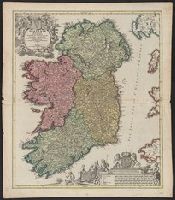
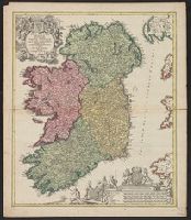
- Beinecke Rare Book and Manuscript Library > Hiberniae regnum tam in praecipuas Ultoniae, Connaciae, Laceniae et Momoniae [cartographic material] : quam in minores earundem provincias et ditiones divisum ex prototype Guil. Petty-Vischeriano deductu et exhibitum / a Joh. Bapt. Homanno
- Creator:
- Homann, Johann Baptist, 1663-1724
Visscher, Nicolaes, 1649-1702
- Published / Created:
- 1715?]
- Call Number:
- 327 1696
- Container / Volume:
- BRBL_00072
- Image Count:
- 1
- Resource Type:
- Maps, Atlases & Globes
- Found in:
- Beinecke Rare Book and Manuscript Library > Hiberniae regnum tam in praecipuas Ultoniae, Connaciae, Laceniae et Momoniae [cartographic material] : quam in minores earundem provincias et ditiones divisum ex prototype Guil. Petty-Vischeriano deductu et exhibitum / a Joh. Bapt. Homanno.
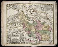
- Creator:
- Homann, Johann Baptist, 1663-1724
- Published / Created:
- ca. 1724
- Call Number:
- 1975 Folio 31
- Collection Title:
- [Atlas factice of 42 maps, produced by the Homann Erben firm]
- Image Count:
- 1
- Found in:
- Beinecke Rare Book and Manuscript Library > Imperii Persici in omnes suas provincias (tam veteribus quam modernis earundem nominibus signatas) [cartographic material] : exacte divisi nova tabula geographica / quam ex praecipuis Olearii, Tavernieri, Relandi aliorumque recentium authoreum scriptis co
- Creator:
- Homann Erben (Firm)
Homann, Johann Baptist, 1663-1724
- Published / Created:
- [1741?]
- Call Number:
- 1983 Folio 23
- Collection Title:
- [Atlas factice of 50 maps, primarily by Johann Baptist Homann and/or issued by the Homann Erben
- Image Count:
- 1
- Found in:
- Beinecke Rare Book and Manuscript Library > Imperii Romano Germanici in svos statvs et circvlos divisi tabvla generalis in ufus iuventutis erundiendae accommodata