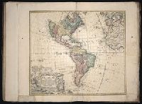
Appears in various eds. of Atlas geographicus maior., Includes German text relating to English and French territorial claims., Neat lines measures 45.8 x 50.8 cm. on sheet 50 x 57.5 cm. Ms. note on verso: No. 151, Nord America nach d'Anville. Franklin Collection no. 131 1756-9., Place names and descriptive notes in English., Prime meridian: Ferro and London., and Relief shown pictorially.
Publisher:
[Homann Erben],
Subject (Geographic):
North America--Maps--Early works to 1800 and United States--History--French and Indian War, 1755-1763--Maps--Early works to 1800
Subject (Name):
Anville, Jean Baptiste Bourguignon d', 1697-1782 and Homann Erben (Firm). Atlas geographicus maior
755 1756E: Mounted on paper. Neat line measures 45.9 x 51 cm. on sheet 46 x 51.2 cm. Ms. no.: 54., Includes German text relating to English and French territorial claims., Prime meridian: Ferro and London., Relief sh, and Sheet measures 49.5 x 57.2 cm.
Publisher:
[Homann Erben],
Subject (Geographic):
North America--Maps--Early works to 1800 and United States--History--French and Indian War, 1755-1763--Maps--Early works to 1800
Subject (Name):
Anville, Jean Baptiste Bourguignon d', 1697-1782 and Homann Erben (Firm). Atlas geographicus maior
Appears in various eds. of Atlas geographicus maior., Includes German text relating to English and French territorial claims., Mounted on paper. Neat line measures 45.9 x 51 cm. on sheet 46 x 51.2 cm. Ms. no.: 54., and Place names and descriptive notes in Englis
Publisher:
[Homann Erben],
Subject (Geographic):
North America--Maps--Early works to 1800 and United States--History--French and Indian War, 1755-1763--Maps--Early works to 1800
Subject (Name):
Anville, Jean Baptiste Bourguignon d', 1697-1782 and Homann Erben (Firm). Atlas geographicus maior
Appears in various eds. of Atlas geographicus maior., Includes German text relating to English and French territorial claims., Place names and descriptive notes in English., Prime meridian: Ferro and London., Relief shown pictorially., and Sheet measures 47.1 x 52 cm. Ms. no. on verso: No. 5. Cross Collection no. 194.
Publisher:
[Homann Erben],
Subject (Geographic):
North America--Maps--Early works to 1800 and United States--History--French and Indian War, 1755-1763--Maps--Early works to 1800
Subject (Name):
Anville, Jean Baptiste Bourguignon d', 1697-1782 and Homann Erben (Firm). Atlas geographicus maior
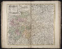
Plan du port et ville de Mahon, du Fort. St. Philippe et ses fortifications
Description:
Includes 2 insets, one showing the islands and the western part of the Mediterranean, and, "Plan du port et ville de Mahon, du Fort. St. Philippe et ses fortifications.", Relief shown by hachures., and Watermark. Manuscript number in upper right corner: 53. From the Karpinski-von Wieser Map Collection.
Publisher:
Communiquée au public par les Hertiers de Homann
Subject (Geographic):
Ibiza (Spain)--Maps--Early works to 1800., Majorca (Spain)--Maps--Early works to 1800., Minorca (Spain)--Maps--Early works to 1800., and St. Philip's Castle (Minorca)--Maps--Early works to 1800.
Subject (Name):
Dorn, Sebastian
Subject (Topic):
Fortifications--Spain--Minorca--Maps--Early works to 1800. and Harbors--Spain--Mahón--Maps--Early works to 1800.
Homann Erben (Firm) Zollmann, Friedrich, 1690-1762 Zuerner, Adam Friedrich, 1680-1742
Published / Created:
1757
Call Number:
1977 Folio 177
Image Count:
3
Resource Type:
Maps, Atlases & Globes
Description:
Includes ill., Relief shown pictorially., Scales given in "mill. Geogr. seu Germanica" and "milliaria Gallica.", and Stamp on verso: 285. Ms. notes on verso. Hand col. Sheet measures 54.8 x 66.7 cm. No. 18 of 34 maps bound together.