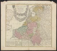
Carte des XVII. provinces ou de l'Allemagne inferievre, dresseé suivant la projection stereographique, et appüyée par les mesures faites de Mess. Cassini, Snellius et Mouschenbrok, par Mr. Tob. Majer de la Societé geographique, et publiée par les Her
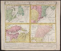
Gros-Britannische Colonie-Lænder in Nord-America, in accuraten Special-Mappen nach den London. Originalien gretreulich mitgetheilt und heraussgegeben von Homaennischen Erben
Description:
In Latin, German and English.
Publisher:
Homannianis Hered.,
Subject (Geographic):
Atlantic Coast (Canada)--Maps--Early works to 1800, Atlantic Coast (U.S.)--Maps--Early works to 1800, and Great Britain--Colonies--America--Maps--Early works to 1800
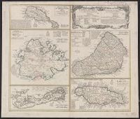
Antigua--Maps--Early works to 1800, B, Barbados--Maps--Early works to 1800, Jamaica--Maps--Early works to 1800, Saint Kitts and Nevis--Maps--Early works to 1800, and West Indies--Maps--Early works to 1800
Antigua--Maps--Early works to 1800, Barbados--Maps--Early works to 1800, Bermuda Islands--Maps--Early works to 1800, Jamaica--Maps--Early works to 1800, and Saint Kitts and Nevis--Maps--Early works to 1800
Appears in various eds. of Atlas geographicus maior., Includes German text relating to English and French territorial claims., Neat lines measures 45.8 x 50.8 cm. on sheet 50 x 57.5 cm. Ms. note on verso: No. 151, Nord America nach d'Anville. Franklin Collection no. 131 1756-9., Place names and descriptive notes in English., Prime meridian: Ferro and London., and Relief shown pictorially.
Publisher:
[Homann Erben],
Subject (Geographic):
North America--Maps--Early works to 1800 and United States--History--French and Indian War, 1755-1763--Maps--Early works to 1800
Subject (Name):
Anville, Jean Baptiste Bourguignon d', 1697-1782 and Homann Erben (Firm). Atlas geographicus maior
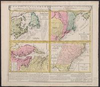
755 1756E: Mounted on paper. Neat line measures 45.9 x 51 cm. on sheet 46 x 51.2 cm. Ms. no.: 54., Includes German text relating to English and French territorial claims., Prime meridian: Ferro and London., Relief sh, and Sheet measures 49.5 x 57.2 cm.
Publisher:
[Homann Erben],
Subject (Geographic):
North America--Maps--Early works to 1800 and United States--History--French and Indian War, 1755-1763--Maps--Early works to 1800
Subject (Name):
Anville, Jean Baptiste Bourguignon d', 1697-1782 and Homann Erben (Firm). Atlas geographicus maior
Appears in various eds. of Atlas geographicus maior., Includes German text relating to English and French territorial claims., Mounted on paper. Neat line measures 45.9 x 51 cm. on sheet 46 x 51.2 cm. Ms. no.: 54., and Place names and descriptive notes in Englis
Publisher:
[Homann Erben],
Subject (Geographic):
North America--Maps--Early works to 1800 and United States--History--French and Indian War, 1755-1763--Maps--Early works to 1800
Subject (Name):
Anville, Jean Baptiste Bourguignon d', 1697-1782 and Homann Erben (Firm). Atlas geographicus maior
Appears in various eds. of Atlas geographicus maior., Includes German text relating to English and French territorial claims., Place names and descriptive notes in English., Prime meridian: Ferro and London., Relief shown pictorially., and Sheet measures 47.1 x 52 cm. Ms. no. on verso: No. 5. Cross Collection no. 194.
Publisher:
[Homann Erben],
Subject (Geographic):
North America--Maps--Early works to 1800 and United States--History--French and Indian War, 1755-1763--Maps--Early works to 1800
Subject (Name):
Anville, Jean Baptiste Bourguignon d', 1697-1782 and Homann Erben (Firm). Atlas geographicus maior