Skip to search
Skip to main content
Skip to first result
Search
You Searched For
Extent of Digitization
Completely digitized
Language
Latin
Creator
Jansson, Jan, 1588-1664
Search Results
Creator:
Published / Created:
[ca. 1647]
Call Number:
911 1652
Container / Volume:
BRBL_00668
Image Count:
2
Resource Type:
Maps, Atlases & Globes
Alternative Title:
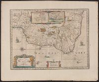
Baya de todos os Sanctos. and Villa d'Olinda de Pernambuco.
Description:
Bar scales in "Milliaria Germanica communia" and "Milliaria Gallica communia."
Publisher:
Joannes Janssonius excudit,
Subject (Geographic):
Brazil--Maps--Early works to 1800
Subject (Name):
Jansson, Jan, 1588-1664. Novus atlas. Dutch
Found in:
Beinecke Rare Book and Manuscript Library > Accuratissima Brasiliae tabula.
Creator:
Published / Created:
ca. 1662?]
Call Number:
53 1662
Container / Volume:
BRBL_00283
Image Count:
2
Resource Type:
Maps, Atlases & Globes
Description:
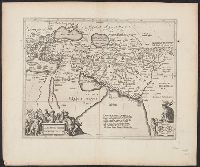
From: Nieuwen atlas ... Amstelodami : Apud Ioannem Ianssonium, [1662?].
Publisher:
Jan Jansson,
Subject (Geographic):
Middle East--Maps--Early works to 1800
Subject (Name):
Jansson, Jan, 1588-1664. Atlas novus. Dutch
Found in:
Beinecke Rare Book and Manuscript Library > Alexandri Magni Macedonis expeditio.
Creator:
Published / Created:
[between 1641 and 1658?]
Call Number:
70 165X
Container / Volume:
BRBL_00353
Image Count:
2
Resource Type:
Maps, Atlases & Globes
Description:
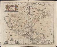
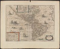
Covers North America, Cent
Publisher:
excudit Ioannes Ianssonius,
Subject (Geographic):
North America--Maps--Early works to 1800
Subject (Name):
Jansson, Jan, 1588-1664. Atlas novus. Dutch
Found in:
Beinecke Rare Book and Manuscript Library > America Septentrionalis.
Creator:
Published / Created:
[between 1641 and 1658?]
Call Number:
70 165XB
Container / Volume:
BRBL_00353
Image Count:
2
Resource Type:
Maps, Atlases & Globes
Description:
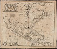
Covers Nort
Publisher:
excudit Ioannes Ianssonius,
Subject (Geographic):
North America--Maps--Early works to 1800
Found in:
Beinecke Rare Book and Manuscript Library > America Septentrionalis.
Creator:
Published / Created:
[1652?]
Call Number:
70 165XA
Container / Volume:
BRBL_00353
Image Count:
2
Resource Type:
Maps, Atlases & Globes
Description:
Appears in various eds. of Jansson's Nieuwen atlas.
Publisher:
Excudit Ioannes Ianssonius,
Subject (Geographic):
America--Maps--Early works to 1800
Subject (Name):
Jansson, Jan, 1588-1664. Atlas novus. Dutch
Found in:
Beinecke Rare Book and Manuscript Library > America noviter delineata.
Creator:
Published / Created:
[1662]
Call Number:
480 1662
Container / Volume:
BRBL_00265
Image Count:
2
Resource Type:
Maps, Atlases & Globes
Alternative Title:
Attica, Megarica, Corinthiaca, Boeotia, Phocis
Description:
From Janssonius's Niewen atlas ... Amstelodami : Apud Ioannem Ianssonium, 1662.
Publisher:
Apud Joannem Janssonium,
Subject (Geographic):
Greece--Maps--Early works to 1800
Subject (Name):
Jansson, Jan, 1588-1664. Atlas novus. Dutch
Found in:
Beinecke Rare Book and Manuscript Library > Attica, Mecarica, Corinthiaca, Boeotia, Phocis, Locri / ex clarissimi D.I. Velli M.D., delineatione.
Creator:
Published / Created:
[ca. 1680?]
Call Number:
1983 Folio 19
Image Count:
2
Description:
BEIN 1983 Folio 19: Imperfect: mutilated along fold and edges, with some loss of text and cartouche [top portion of cartouche reproduced in ms.]. Reinforced along edges with manuscript and printed waste. Sheet measures 40.2 x 49.0 cm. No. 76 of 92 map...
Publisher:
Apud Ioannem Ianssonium
Subject (Geographic):
Bohemia (Czech Republic)
Found in:
Beinecke Rare Book and Manuscript Library > Bohemia [cartographic material].
Creator:
Published / Created:
[ca. 1633]
Call Number:
1983 Folio 19
Image Count:
1
Alternative Title:
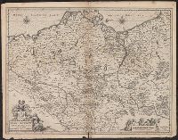
Brandebvrgvm Marchionatvs, cum Ducatibus Pomeraniae et Meklenbvrgi
Description:
BEIN 1983 Folio 19: Imperfect: mutilated along fold, with some loss of text; bar scale cut out and replaced in ms. Reinforced along edges with printed waste. Sheet measures 39.1 x 50.4 cm. No. 78 of 92 maps bound together.
Publisher:
Excudebat Ioannes Ianssonius
Subject (Geographic):
Pomerania (Poland and Germany), Mecklenburg-Vorpommern (Germany), and Brandenburg (Germany : Landkreis)
Found in:
Beinecke Rare Book and Manuscript Library > Brandeburgum Marchionatus, cum Ducatibus Pomeraniae et Meklenburgi
Creator:
Published / Created:
[1636]
Call Number:
367 1630
Container / Volume:
BRBL_00145
Image Count:
2
Resource Type:
Maps, Atlases & Globes
Alternative Title:
Brandebvrgvm Marchionatvs, cum Ducatibus Pomeraniae et Meklenbvrgi
Description:
Bar scale given in "milliaria Germanica communia".
Publisher:
Excudebat Ioannes Ianssonius,
Subject (Geographic):
Brandenburg (Germany : Landkreis)--Maps--Early works to 1800, Mecklenburg-Vorpommern (Germany)--Maps--Early works to 1800, and Pomerania (Poland and Germany)--Maps--Early works to 1800
Subject (Name):
Hondius, Hendrik, 1597-1651. Atlas novus. English and Jansson, Jan, 1588-1664. Atlas novus. English
Found in:
Beinecke Rare Book and Manuscript Library > Brandeburgum Marchionatus, cum Ducatibus Pomeraniae et Meklenburgi.
Creator:
Published / Created:
ca. 1660]
Call Number:
329 1660
Container / Volume:
BRBL_00074
Image Count:
1
Resource Type:
Maps, Atlases & Globes
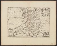
Alternative Title:
Cambriae typvs
Publisher:
Jan Jansson,
Subject (Geographic):
Wales--Maps--Early works to 1800
Found in:
Beinecke Rare Book and Manuscript Library > Cambriae typus [cartographic material] / auctore Humfredo Lhuydo.
Branch:v1.70.9 ,Deployed:2025-10-15T09:50:24-04:00