Skip to search
Skip to main content
Skip to first result
Search
You Searched For
Creator
Keere, Pieter van den, 1571-approximately 1646
Search Results
Creator:
Keere, Pieter van den, 1571-approximately 1646
Published / Created:
[between 1652 and 1684]
Call Number:
BrSides Double Folio 2019 56
Image Count:
1
Resource Type:
Maps, Atlases & Globes
Alternative Title:
Argonautica
Description:
Appeared in various editions of Jan Jansson's Accuratissima orbis antiqui delineatio.
Publisher:
[Jan Jansson],
Subject (Geographic):
Mediterranean Region--Maps--Early works to 1800.
Subject (Name):
Jansson, Jan, 1588-1664. Accuratissima orbis antiqui delineatio.
Subject (Topic):
Argonauts (Greek mythology)--Travel--Maps--Early works to 1800. and Literary landmarks--Mediterranean Region--Maps--Early works to 1800.
Found in:
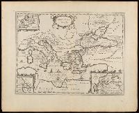
Beinecke Rare Book and Manuscript Library > Argonavtica / Petrus Kaerius caelavit aetatis suae 74.
Creator:
Keere, Pieter van den, 1571-approximately 1646
Published / Created:
[between 1652 and 1684]
Call Number:
36 1630
Container / Volume:
BRBL_00117
Image Count:
1
Resource Type:
Maps, Atlases & Globes
Description:
Appears in Jansson's historical atlas editions from 1652-1684.
Publisher:
Apud Joannem Janssonium,
Subject (Geographic):
Benelux countries--Historical geography--Maps--Early works to 1800., Benelux countries--Maps--Early works to 1800., Europe, Central--Historical geography--Maps--Early works to 1800., Europe, Central--Maps--Early works to 1800., Europe, Eastern--Historical geography--Maps--Early works to 1800., Europe, Eastern--Maps--Early works to 1800., Germany--Historical geography--Maps--Early works to 1800., and Germany--Maps--Early works to 1800.
Subject (Name):
Jansson, Jan, 1588-1664
Subject (Topic):
Ethnology--Europe--Maps--Early works to 1800. and Germanic peoples--Maps--Early works to 1800.
Found in:
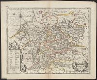
Beinecke Rare Book and Manuscript Library > Germaniae veteris nova descriptio / Petrus Kaerius celavit.
Creator:
Keere, Pieter van den, 1571-approximately 1646
Published / Created:
[between 1652 and 1684]
Call Number:
BrSides Double Folio 2019 62
Image Count:
1
Resource Type:
Maps, Atlases & Globes
Alternative Title:
Gallia Cisalpina
Description:
Appeared in various editions of Jan Jansson's Accuratissima orbis antiqui delineatio.
Publisher:
[Jan Jansson],
Subject (Geographic):
Cisalpine Republic--Maps--Early works to 1800. and Lombardy (Italy)--Maps--Early works to 1800.
Subject (Name):
Jansson, Jan, 1588-1664. Accuratissima orbis antiqui delineatio. and Ortelius, Abraham, 1527-1598
Subject (Topic):
Historical geography--Italy--Lombardy--Maps--Early works to 1800.
Found in:
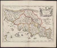
Beinecke Rare Book and Manuscript Library > Italia Gallica, sive, Gallia Cisalpina / ex conatibus geographicis Abrah. Ortelij.
Creator:
Keere, Pieter van den, 1571-approximately 1646
Published / Created:
[between 1652 and 1684]
Call Number:
BrSides Double Folio 2019 60
Image Count:
1
Resource Type:
Maps, Atlases & Globes
Alternative Title:
Nova & accurata Tusciae antiquae descriptio, Nova et accurata Tusciae antiquae descriptio, and Nova et accurata Tvsciae antiqvae descriptio
Description:
Appeared in various editions of Jan Jansson's Accuratissima orbis antiqui delineatio.
Publisher:
[Jan Jansson],
Subject (Geographic):
Tuscany (Italy)--Maps--Early works to 1800.
Subject (Name):
Jansson, Jan, 1588-1664. Accuratissima orbis antiqui delineatio. and Ortelius, Abraham, 1527-1598
Subject (Topic):
Historical geography--Italy--Tuscany--Maps--Early works to 1800.
Found in:
Beinecke Rare Book and Manuscript Library > Nova & accurata Tvsciae antiqvae descriptio / auctore Ab. Ortelio ; Petrus Kaerius caelavit.
Creator:
Keere, Pieter van den, 1571-approximately 1646
Published / Created:
[between 1652 and 1684]
Call Number:
405 1620
Container / Volume:
BRBL_00235
Image Count:
1
Resource Type:
Maps, Atlases & Globes
Alternative Title:
Nova & accurata Tusciae antiquae descriptio, Nova et accurata Tusciae antiquae descriptio, and Nova et accurata Tvsciae antiqvae descriptio
Description:
Appeared in various editions of Jan Jansson's Accuratissima orbis antiqui delineatio.
Publisher:
[Jan Jansson],
Subject (Geographic):
Tuscany (Italy)--Maps--Early works to 1800
Subject (Name):
Jansson, Jan, 1588-1664. Accuratissima orbis antiqui delineatio. and Ortelius, Abraham, 1527-1598
Subject (Topic):
Historical geography--Italy--Tuscany--Maps--Early works to 1800.
Found in:
Beinecke Rare Book and Manuscript Library > Nova & accurata Tvsciae antiqvae descriptio / auctore Ab. Ortelio ; Petrus Kaerius caelavit.
Creator:
Keere, Pieter van den, 1571-approximately 1646
Published / Created:
[1652?]
Call Number:
BrSides Double Folio 2019 66
Image Count:
1
Resource Type:
Maps, Atlases & Globes
Alternative Title:
Pontus Euxinus and Pontvs Euxinvs
Description:
Relief shown pictorially.
Publisher:
[Jan Jansson],
Subject (Geographic):
Black Sea Region and Black Sea Region--History--Maps--Early works to 1800.
Subject (Name):
Jansson, Jan, 1588-1664 and Ortelius, Abraham, 1527-1598
Found in:
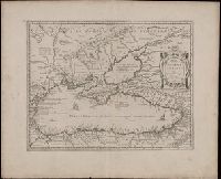
Beinecke Rare Book and Manuscript Library > Pontos Euxeinos = Pontus Euxinus : æquor Iasonio pulsatum remige primum / ex conatibus Abrahami Ortelii ; Petrus Kaerius caelavit.
Creator:
Keere, Pieter van den, 1571-approximately 1646
Published / Created:
[between 1652 and 1684]
Call Number:
BrSides Double Folio 2019 57
Image Count:
1
Resource Type:
Maps, Atlases & Globes
Alternative Title:
Thraciae veteris typus and Thraciae veteris typvs
Description:
Appeared in various editions of Jan Jansson's Accuratissima orbis antiqui delineatio.
Publisher:
[Jan Jansson],
Subject (Geographic):
Bulgaria--Maps--Early works to 1800., Thrace--Maps--Early works to 1800., and Turkey--Maps--Early works to 1800.
Subject (Name):
Jansson, Jan, 1588-1664. Accuratissima orbis antiqui delineatio. and Ortelius, Abraham, 1527-1598
Found in:
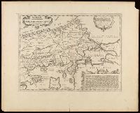
Beinecke Rare Book and Manuscript Library > Thrakē = Thraciae veteris typus / ex conatibus geographicis Abrah. Ortelij. ; Petrus Kaerius caelavit.
Creator:
Keere, Pieter van den, 1571-approximately 1646
Published / Created:
[between 1652 and 1684]
Call Number:
BrSides Double Folio 2019 58
Image Count:
1
Resource Type:
Maps, Atlases & Globes
Alternative Title:
Vetus descriptio Daciarum nec non Moesiarum
Description:
Appeared in various editions of Jan Jansson's Accuratissima orbis antiqui delineatio.
Publisher:
[Jan Jansson],
Subject (Geographic):
Bulgaria--Maps--Early works to 1800., Dacia--Maps--Early works to 1800., Moesia--Maps--Early works to 1800., and Romania--Maps--Early works to 1800.
Subject (Name):
Jansson, Jan, 1588-1664. Accuratissima orbis antiqui delineatio.
Found in:
Beinecke Rare Book and Manuscript Library > Vetvs descriptio Daciarum nec non Moesiarvm : vrbes incognitae positionis huc referendae sunt / Petrus Kaerius caelavit.
Branch:v1.68.7 ,Deployed:2025-07-09T09:08:31-04:00