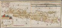
Also shows p, Includes text, col. view of Jakarta, inset of Jakarta, and some cities are marked with gilt., Library copy joined to form 1 sheet., Pars occidentalis --, Prime meridian: Ferro., and Title and notes in Latin. Place-names and scale statements in Dutch.
Publisher:
by Gerard van Keulen aan de Nieuwe brug met previlegie,
Subject (Geographic):
Jakarta (Indonesia)--Maps--Early works to 1800 and Java (Indonesia)--Maps--Early works to 1800
Keulen, Gerard van Keulen, Johannes van, fl. 1726-1753. Nieuwe groote lichtende zee-fakkel
Call Number:
303cea 1680
Container / Volume:
BRBL_00033
Image Count:
1
Resource Type:
Maps, Atlases & Globes
Alternative Title:
New sea map of the whole North Sea and Nouvelle carte marine generale de la Mer du Nord
Description:
Appeared in Joannes van Keulen's De Nieuwe groote, Backed with paper. Sheets measure 61.0 x 52.2 cm or smaller., Includes five bar scales., Relief shown pictorially; depth shown by soundings., and Scale estimated by measurement of degree of latitude.