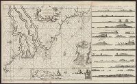
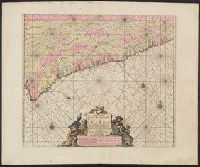
"By Joannes van Keulen, Boek-vercooper en graadboog maecker, by de nieuwe brugh in de gecroonde Lootsman.", "Met prevelegie voor 15 Jaer.", Covers coastal West Af, Depths shown by soundings., Has watermarks., In lower right: 2., and Oriented with north to the left.
Publisher:
Joannes van Keulen,
Subject (Geographic):
Africa, West--Maps--Early works to 1800 and Africa, West--Nautical charts--Early works to 1800
Subject (Topic):
Coasts--Africa, West--Maps--Early works to 1800 and Nautical charts--Africa, West--Early works to 1800
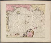
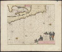
"By Joaunes van Keulen, Boek-verkooper en graet boogh-maker, over de Niewe brug in de gekroonde Loots.", "Met previlegie voor 15, Appeared in Keulen's De groote nieuwe vermeerderde zee-atlas ofte water-waereld., and Includes decorative cartouche and rhumb lines.
Publisher:
Joaunes van Keulen,
Subject (Name):
Keulen, Johannes van, 1654-1715. Groote nieuwe vermeerderde zee-atlas ofte water-waereld
Subject (Topic):
Coasts--Cameroon--Maps--Early works to 1800, Coasts--Equatorial Guinea--Early works to 1800, Coasts--Gabon--Maps--Early works to 1800, Nautical charts--Cameroon--Early works to 1800, and Nautical charts--Equatorial
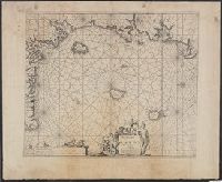
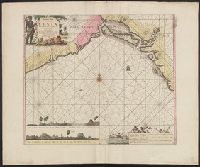
"By Joaunes van Keulen, Appeared in Keulen's De groote nieuwe vermeerderde zee-atlas ofte water-waereld., Copy 2: Not colored. Sheet measures 60 x 73 cm., Covers coasts of Gabon, Cameroon, and Equatorial Guinea., and Includes decorative cartouche and rhumb lines.
Publisher:
Joaunes van Keulen,
Subject (Name):
Keulen, Johannes van, 1654-1715. Groote nieuwe vermeerderde zee-atlas ofte water-waereld
Subject (Topic):
Coasts--Cameroon--Maps--Early works to 1800, Coasts--Equatorial Guinea--Early works to 1800, Coasts--Gabon--Maps--Early works to 1800, Nautical charts--Cameroon--Early works to 1800, and Nautical charts--Equatorial
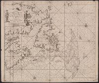
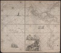
"22" in lower left and lower right corners., Appears in Keulen's De groote nieuwe vermeerderde zee-atlas ofte water-waereld., Ms., Shoal added around Accadie., and Shows Gulf of St. Lawrence from Newfoundland to the Gaspé, soundings indicated on the Grand Banks.
Publisher:
By Johannes van Keulen ...,
Subject (Geographic):
Atlantic Provinces--Maps--Early works to 1800 and Saint Lawrence, Gulf of--Maps--Early works to 1800
Subject (Name):
Keulen, Johannes van, 1654-1715. Groote nieuwe vermeerderde zee-atlas ofte water-waereld
"Met prevelegie voor 15 jaer.", Includes ornamental cartouche, rhumb lines, and ill., and Subtitle: Van C. tres Puntas tot Acara, daer mede in verthoont word, alle binnens lands Proventien, wat aldaer voor Coopmanschapppen verhandelt wort, als mede de zeden en
Publisher:
Joannes van Keulen ... byae Nieuwe brugh inde gekroonde Lootsman,
Subject (Name):
Keulen, Johannes van, 1654-1715. Groote nieuwe vermeerderde zee-atlas ofte water-waereld
Subject (Topic):
Coasts--Ghana--Maps--Early works to 1800 and Nautical charts--Ghana--Early works to 1800
Appears in the author's De groote nieuwe vermeerderde zee-atlas ofte water-waereld. 1709., Depths shown by soundings., In bottom right: 9., Includes inset of "Aldus verthoont Agoa de Saldanha," ornamental cartouche, rhumb lines, and ill., and Oriented with north
Publisher:
Joannes van Keulen ... aende Nieuwebrug in gekroonde Lootsman,
Subject (Name):
Keulen, Johannes van, 1654-1715. Groote nieuwe vermeerderde zee-atlas ofte water-waereld
Subject (Topic):
Coasts--Angola--Maps--Early works to 1800, Coasts--Namibia--Maps--Early works to 1800, Coasts--South Africa--Cape of Good Hope--Maps--Early works to 1800, and Nautical charts--Atlantic coast (Africa)--Early works to 1800
"Met prevelegie voor 15 jaer.", Appears in the author's De groote nieuwe vermeerderde zee-atlas ofte water-waereld. 1709., Depths shown by soundings., In bottom right: 5., and Includes coastal profile, ornamental cartouche, rhumb lines, and ill.
Publisher:
Joannes van Keulen ... aende Nieuwe brug inde gecroonde Lootsman,
Subject (Name):
Keulen, Johannes van, 1654-1715. Groote nieuwe vermeerderde zee-atlas ofte water-waereld
Subject (Topic):
Coasts--Benin--Maps--Early works to 1800, Coasts--Nigeria--Maps--Early works to 1800, and Nautical charts--Benin, Bight of--Early works to 1800
"Met Priviligie voor 15 Iaar.", From Keulen's Groote nieuwe vermeerderde zee-atlas ofte water-waereld / Johannes van Keulen., Map, State 1. Imperfect: small hole in lower right corner, with no loss of text. Cross Collection 69., and Title in cartouche.
Publisher:
By Ioannes van Keulen, aen de Nieuwe brugh in de Gekroonde Lootsman,
Subject (Geographic):
North America--Maps--Early works to 1800, Pacific Area--Maps--Early works to 1800, and South America--Maps--Early works to 1800
Subject (Name):
Keulen, Johannes van, 1654-1715. Groote nieuwe vermeerderde zee-atlas ofte water-waereld
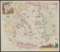
"Met priviligie voor 15 Iaar.", Appears in the author's De groote niewe vermeerderde zee-atlas ofte water-waereld., Dutch, with Latin place names., Has watermark., and Includes col. ill., decorative cartouche, and rhumb lines.
Publisher:
By Ioannes van Keulen, boeck verkooper en graad boogh maker, aen de N:Brugh inde gekroonde Loots,
Subject (Geographic):
Aegean Islands (Greece and Turkey)--Maps--Early works to 1800 and Crete (Greece)--Maps--Early works to 1800
Subject (Name):
Keulen, Johannes van, 1654-1715. Groote nieuwe vermeerderde zee-atlas ofte water-waereld