"Iohan. Senex scu, Imprint derived from other maps in the same atlas., London meridian., Ms. no. on verso: 34. Sheet measures 53 x 68 cm. Cross Collection no. 96., Relief shown pictorially., and Shows boundaries, forests, rivers, roads and settlements, with notes.
Publisher:
John Senex,
Subject (Geographic):
Mediterranean Region--Historical geography--Early works to 1800--Maps
Has watermark., Includes "Admonitio" and 4 bar scales., Prime meridian: Ferro., Relief shown pictorially., Sheet measures 55.7 x 67.2 cm., and Shows east coast of Brazil.
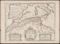
Has watermark., In French., Prime meridians: Paris and Ferro., Relief shown pictorially., and Title in decorative cartouche in upper left; note in smaller cartouche in lower left.
Publisher:
Chez l'auteur, Rue des Noyers, avec privilège d'auteur,
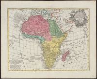
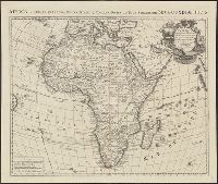
Africa accurate in imperia, regna, status & populos divisa, ad usum Ludovici XV Galliarum Regis and Africa accurate in imperia, regna, status et populos divisa, ad usum Ludovici XV Galliarum Regis
Description:
In French and Latin.
Publisher:
Chez I. Covens et C. Mortier,
Subject (Geographic):
Africa--Maps--Earlyworksto1800
Subject (Name):
Condet, Johannes, 1711-1781 and Cóvens et Mortier
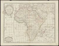
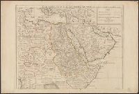
"Avec privilege pour 20 ans.", Covers Africa east of Algeria and north of the equator., Has watermark., Includes text., Relief shown pictorially., and Sheet measures 54 x 73 cm. Ms. no. on verso: 77.
Publisher:
Chez l'auteur sur le Quai de l'Horloge a l'Aigle d'Or,
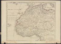
"Avec privilege pour 20 ans.", Covers Africa east of Algeria and north of the equator., Has watermark., Includes text., Relief shown pictorially., and Sheet measures 54 x 73 cm. Ms. no. on verso: 77.
Publisher:
Chez l'auteur sur le Quai de l'Horloge a l'Aigle d'Or,
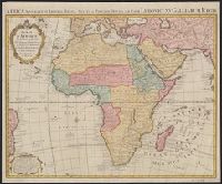
Africa accuraté in imperia, regna, status & populos divisa, ad usum serenissimi Bourgundiae Ducis.
Description:
"Avec privil[ège].", Appeared in various eds. of Cóvens et Mortier's Atlas noveau; cf. Koeman, C. Atlantes Neerlandici, Coverage includes the eastern coast of Brazil., II, C & M 3 and 4., Includes four bar scales., and Relief shown pictorially.
"Avec privil, "The words 'premier geographe du Roi' added in the title ... [indicate] that [a map] could not have been issued before 1718 when [De l'Isle] was appointed to that office"--Tooley, R.V. Guide to maps of Africa, p. 68., and Relief shown pictorially.
Publisher:
chez l'auteur fur le Quai de l'Horloge a l'Aigle d'Or,