Skip to search
Skip to main content
Skip to first result
Search
You Searched For
Extent of Digitization
Completely digitized
Creator
La Rue, Philippe de
Creator
Mariette, Pierre, 1603-1657
New Search
Search Results
Creator:
Published / Created:
1651
Call Number:
1983 Folio 19
Collection Title:
[Atlas factice of 96 maps by Blaeu, Visscher, Jansson, Hondius and others]
Image Count:
1
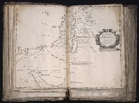
Description:
Imperfect: trimmed, with some loss of text and graticule; torn along fold, with partial loss of text. Sheet measures 40.6 x 53.2 cm. No. 18 of 92 maps bound together.
Publisher:
Sumptibus Petri Mariette ...
Subject (Geographic):
Jerusalem --History --Maps --Early works to 1800, Palestine --History --638-1917 --Maps, and Palestine --Maps --Early works to 1800
Found in:
Beinecke Rare Book and Manuscript Library > Pinax geographicus Patriarchatus Hierosolymitani ... / auctore Ph. de la Rue ... ; J. Sommer sculp
Creator:
Published / Created:
1651
Call Number:
1983 Folio 19
Collection Title:
[Atlas factice of 96 maps by Blaeu, Visscher, Jansson, Hondius and others]
Image Count:
1
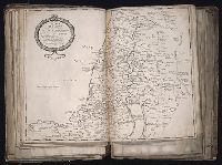
Description:
Imperfect: torn along fold, with partial loss of text. Sheet measures 40.9 x 54 cm. No. 19 of 92 maps bound together.
Publisher:
Sumptibus Petri Mariette ...
Subject (Geographic):
Palestine --Historical geography --Maps --Early works to 1800
Subject (Name):
Bible. O.T. --Geography --Maps --Early works to 1800
Found in:
Beinecke Rare Book and Manuscript Library > Regnum Judeorum in filios Herodis magni per Tetrarchias diuisum ad tempora Christi domini ... / auctore Ph. de la Rue ... ; Jean Sommer, sculpsit
Creator:
Published / Created:
[1651]
Call Number:
1983 Folio 19
Collection Title:
[Atlas factice of 96 maps by Blaeu, Visscher, Jansson, Hondius and others]
Image Count:
1
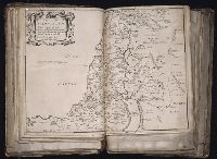
Description:
Imperfect: torn near fold, with no loss of text. Sheet measures 39.5 x 54.3 cm. No. 20 of 92 maps bound together.
Publisher:
Sumptibus Petri Mariette ...
Subject (Geographic):
Palestine --Historical geography --Maps --Early works to 1800
Subject (Name):
Bible. O.T. --Geography --Maps --Early works to 1800
Found in:
Beinecke Rare Book and Manuscript Library > Regnum Salomonicum, seu, Tabula digesta ad Libros Judicum, Regum, Paral, et Prophetarum per Eparchias XII Mox Regna duo : Cum Privil. Regis Christ. / Auctore Ph. de la Rue ...
Branch:v1.61.6 ,Deployed:2024-06-12T09:55:19-04:00