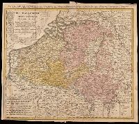
Belgium Catholicum seu decem provinciae Germaniae inferioris and Carte des Pais Bas catholiques où des X provinces de l'Allegmagne inférieure, etc. dessinée au juste selon les exactes observations astronomiques et opérations géometriques des Messur. Cass
Description:
"Avec privil. Imperial" above neat line., Includes 8 bar scales., Includes coats-of-arms of ten provinces., Relief shown pictorially., and Watermark. Manuscript number in upper right corner: 262[?]. From the Karpinski-von Wieser Map Collection.
Publisher:
Edentibus Homannianis heredib.,
Subject (Geographic):
Belgium--Maps--Early works to 1800. and Luxembourg--Maps--Early works to 1800.
Subject (Name):
Cassini, César-François, 1714-1784, Homann Erben (Firm), and Snellius, Willebrord, 1580-1626