"Longitude west from London.", First impression of 3d ed., Includes text and inset "A new map of Hudson's Bay and Labrador from the late surveys of those coasts.", and Relief shown pictorially.
Publisher:
Printed for Jefferys and Faden, geographers to the King,
Subject (Geographic):
NorthAmerica--Maps--Early works to
Subject (Name):
Jefferys and Faden, London and Kitchin, Thomas, d. 1784
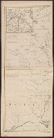
Fourth ed., In bottom margin: Publish'd by the author Febry 13th 1755 according to act of Parliament., Includes text and inset "A new map of Hudson's Bay and Labrador from the late surveys of those coasts.", Relief shown pictorially., and Yale's copy stamped on b
Publisher:
Printed for Jefferys and Faden, geographers to the King,
Subject (Geographic):
NorthAmerica--Maps--Early works to
Subject (Name):
Jefferys and Faden, London and Kitchin, Thomas, d. 1784
First impression of 3d French ed., Includes text and inset "Nouvelle carte de la baye d'Hudson et de Labrador selon les dernieres cartes levées sur les lieux.", Prime meridian: London., Relief shown pictorially., and Title in French and German.
Subject (Geographic):
NorthAmerica--Maps--Early works to
Subject (Name):
Hawkins, M., fl. 1776-1792 and Le Rouge, Georges-Louis
4th impression of 3d French ed. Cf. Ristow, W.W. A la carte, p. 112., Includes text and inset "Nouvelle carte de la baye d'Hudson et de Labrador selon les dernieres cartes levées sur les lieux.", Prime meridian: London., Relief shown pictorially., and Title in F
Publisher:
Le Rouge?,
Subject (Geographic):
NorthAmerica--Maps--Early works to
Subject (Name):
Hawkins, M., fl. 1776-1792 and Le Rouge, Georges-Louis