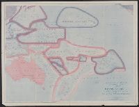
1. Sovereignty and mandate boundary lines in 1921 of the islands of the Pacific / prepared in the Map Creator: National Geographic Society (U.S.). Map Dept Published / Created: c1921. Call Number: 23fd 1921 Container / Volume: BRBL_00021 Image Count: 1 Resource Type: Maps, Atlases & Globes Found in: Beinecke Rare Book and Manuscript Library > Sovereignty and mandate boundary lines in 1921 of the islands of the Pacific / prepared in the Map Department of the National Geographic Society for the National Geographic magazine ; drawn by Albert H. Bumstead and James M. Darley.
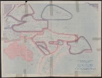
2. Sovereignty and mandate boundary lines in 1921 of the islands of the Pacific / prepared in the Map Creator: National Geographic Society (U.S.). Map Dept Published / Created: c1921. Call Number: 23fd 1921 Container / Volume: BRBL_00021 Image Count: 1 Resource Type: Maps, Atlases & Globes Found in: Beinecke Rare Book and Manuscript Library > Sovereignty and mandate boundary lines in 1921 of the islands of the Pacific / prepared in the Map Department of the National Geographic Society for the National Geographic magazine ; drawn by Albert H. Bumstead and James M. Darley.