Skip to search
Skip to main content
Skip to first result
Search
You Searched For
Extent of Digitization
Completely digitized
Creator
Nicholson, W. L
Search Results
Creator:
Published / Created:
1863
Call Number:
783 1863B
Container / Volume:
BRBL_00509
Image Count:
1
Resource Type:
Maps, Atlases & Globes
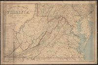
Description:
Also covers Delaware, Maryland, West Virginia and parts of adjacent states.
Publisher:
The Office,
Subject (Geographic):
Delaware--Maps, Maryland--Maps, Virginia--Maps, and West Virginia--Maps
Subject (Name):
Bache, A. D. (Alexander Dallas), 1806-1867, Krebs, Charles G, and United States Coast Survey
Found in:
Beinecke Rare Book and Manuscript Library > Map of the state of Virginia / compiled from the best authorities and printed at the Coast Survey Office, A.D. Bache, supdt. ; compiled by W.L. Nicholson ; lith. by Chas. G. Krebs.
Creator:
Published / Created:
[1863]
Call Number:
754 1863B
Container / Volume:
BRBL_00416
Image Count:
1
Resource Type:
Maps, Atlases & Globes
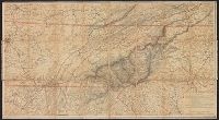
Description:
Copy 2 Imperfect: title along head of map wanting. Copy 2: mounted on linen. On verso: "Wallingford Public Library" plate, stamped "discard"; ms. note "Lt. Col. Goddard."
Publisher:
U.S. Coast Survey,
Subject (Geographic):
North Carolina--Maps and Tennessee--Maps
Subject (Name):
Hawley, Joseph R. (Joseph Roswell), 1826-1905, Krebs, Charles G, Lindenkohl, A, Lindenkohl, H. (Henry), and U.S. Coast and Geodetic Survey
Found in:
Beinecke Rare Book and Manuscript Library > Mountain region of North Carolina and Tennessee / compiled by W.L. Nicholson & A. Lindenkohl, 1863 ; drawn by A. Lindenkohl ; H. Lindenkohl & Chas. G. Krebs, lith.
Creator:
Published / Created:
[1863]
Call Number:
754 1863B
Container / Volume:
BRBL_00416
Image Count:
1
Resource Type:
Maps, Atlases & Globes
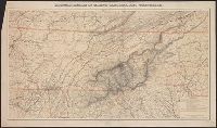
Description:
Includes list of "Authorities."
Publisher:
U.S. Coast Survey,
Subject (Geographic):
North Carolina--Maps and Tennessee--Maps
Subject (Name):
Hawley, Joseph R. (Joseph Roswell), 1826-1905, Krebs, Charles G, Lindenkohl, A, Lindenkohl, H. (Henry), and U.S. Coast and Geodetic Survey
Found in:
Beinecke Rare Book and Manuscript Library > Mountain region of North Carolina and Tennessee / compiled by W.L. Nicholson & A. Lindenkohl, 1863 ; drawn by A. Lindenkohl ; H. Lindenkohl & Chas. G. Krebs, lith.
Creator:
Published / Created:
1881?]
Call Number:
818 1881
Container / Volume:
BRBL_00565
Image Count:
2
Resource Type:
Maps, Atlases & Globes
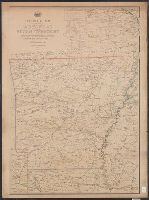
Description:
"The service on this diagram brought up to date of Oct. 1st 1881."
Publisher:
The Dept.,
Subject (Geographic):
Arkansas--Maps and Indian Territory--Maps
Subject (Name):
United States. Post Office Dept
Subject (Topic):
Postal service--Arkansas--Maps and Postal service--Indian Territory--Maps
Found in:
Beinecke Rare Book and Manuscript Library > Post route map of the state of Arkansas and of the Indian Territory : with adjacent portions of Mississippi, Tennessee, Missouri, Kansas, Texas and Louisiana / designed and constructed under the orders of Postmaster General D.M. Key, by W.L. Nicholson, to
Creator:
Published / Created:
[1879?]
Call Number:
796gmd 1879
Container / Volume:
BRBL_00531
Image Count:
2
Resource Type:
Maps, Atlases & Globes
Alternative Title:
Eastern part, post route map of the state of Texas. and Western part, post route map of the state of Texas.
Description:
"The first edition was issued in 1878."
Publisher:
Post Office Dept.,
Subject (Geographic):
Texas--Maps
Subject (Name):
Key, David McKendree, 1824-1900, Streeter, Thomas W.--(Thomas Winthrop),--1883-1965--Ownership, and United States. Post Office Dept
Subject (Topic):
Postal service--Texas--Maps
Found in:
Beinecke Rare Book and Manuscript Library > Post route map of the state of Texas : with adjacent parts of Louisiana, Arkansas, Indian Territory, and of the Republic of Mexico / designed and constructed under the orders of Postmaster General D.M. Key by W.L. Nicholson.
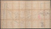
Creator:
Published / Created:
19--?]
Call Number:
80gmd 1878
Container / Volume:
BRBL_00538
Image Count:
6
Resource Type:
Maps, Atlases & Globes
Description:
"Drawn by A.F. Dinsmore."
Publisher:
s.n.,
Subject (Geographic):
West (U.S.)--Maps
Subject (Name):
Dinsmore, A. F and United States. Post Office Dept
Subject (Topic):
Postal service--West (U.S.)--Maps
Found in:
Beinecke Rare Book and Manuscript Library > Preliminary post route map of the territories of Montana, Idaho, Wyoming, Utah, Arizona, New Mexico and state of Colorado, with parts of adjacent states and territories / designed and constructed under the orders of D.M. Key by W.L. Nicholson of P.O. Dept
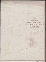
Creator:
Published / Created:
1882?]
Call Number:
831 1882
Container / Volume:
BRBL_00579
Image Count:
1
Resource Type:
Maps, Atlases & Globes
Alternative Title:
Post route map of the territory of Montana.
Description:
"The service on this diagram brought up to date of March 1, 1882."
Publisher:
Post Office Dept.,
Subject (Geographic):
West (U.S.)--Maps
Subject (Name):
United States. Post Office Dept
Subject (Topic):
Postal service--West (U.S.)--Maps
Found in:
Beinecke Rare Book and Manuscript Library > Preliminary post route map of the territories of Montana, Idaho, Wyoming, Utah, Arizona, New Mexico and state of Colorado, with parts of adjacent states and territories / designed and constructed under the orders of Postmaster General D.M. Key by W.L. Nic
Branch:v1.68.6 ,Deployed:2025-07-02T08:09:31-04:00