Skip to search
Skip to main content
Skip to first result
Search
You Searched For
Creator
Rand Avery Supply Co
Search Results
Creator:
Published / Created:
[1890?]
Call Number:
761gme 1890
Container / Volume:
BRBL_00449
Image Count:
1
Resource Type:
Maps, Atlases & Globes
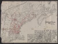
Description:
Shows Bangor and Aroostook Railroad and connecting lines.
Publisher:
Rand Avery Supply Co. ,
Subject (Name):
Bangor and Aroostook Railroad Company--Maps
Subject (Topic):
Railroads--Maine--Maps
Found in:
Beinecke Rare Book and Manuscript Library > Bangor & Aroostook Railroad and connections : including Northern Maine hunting and fishing region.
Creator:
Published / Created:
1902]
Call Number:
762am W588 1902
Container / Volume:
BRBL_00451
Image Count:
2
Resource Type:
Maps, Atlases & Globes
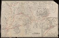
Alternative Title:
Bird's eye map of the White Mountains, reached by Boston & Maine
Description:
"Tourist Season 1902, in effect June 23".
Publisher:
[R.A. Supply Co.,
Subject (Geographic):
White Mountains (N.H. and Me.)--Maps
Subject (Topic):
Railroads--White Mountains (N.H. and Me.)--Maps
Found in:
Beinecke Rare Book and Manuscript Library > Bird's-eye map of the White Mountains, reached by Boston & Maine RR / R.A. Supply Co., eng'rs and printers.
Creator:
Published / Created:
[1911?]
Call Number:
76gme 1910
Container / Volume:
BRBL_00446A
Image Count:
1
Resource Type:
Maps, Atlases & Globes
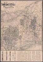
Alternative Title:
Boston and Maine Railroad and connections
Description:
St. Andrews N.B. and about there -- White Mountain region -- Mount Desert Island and vicinity.
Publisher:
The Company,
Subject (Geographic):
New England--Maps
Subject (Name):
Boston and Maine Railroad
Subject (Topic):
Railroads--New England--Maps
Found in:
Beinecke Rare Book and Manuscript Library > Boston & Maine Railroad and connections / Rand Avery Supply Co.
Creator:
Published / Created:
[approximately 1890?]
Call Number:
761gmf 1905
Container / Volume:
BRBL_00449
Image Count:
1
Resource Type:
Maps, Atlases & Globes
Description:
Covers Penobscot Bay area from Rockland to Winter Harbor, Me.
Publisher:
Rand Avery Supply Co.,
Subject (Geographic):
Mount Desert Island (Me.)--Maps and Penobscot Bay Region (Me.)--Maps
Subject (Name):
Eastern Steamship Company--Maps
Subject (Topic):
Steamboat lines--Maine--Maps
Found in:
Beinecke Rare Book and Manuscript Library > Map of Eastern Steamship Co. showing approaches to Mount Desert [cartographic material].
Creator:
Published / Created:
1892]
Call Number:
761 M86 1892
Container / Volume:
BRBL_00448
Image Count:
2
Resource Type:
Maps, Atlases & Globes
Description:
Folded into tan wraps entitled: Map of Mt. Desert Island and the coast of Maine presented by the Maine Central Railroad and Portland-Mt. Desert & Machias Steamboat Co.
Publisher:
Boston & Maine Railroad,
Subject (Geographic):
Hancock County (Me.)--Maps and Mount Desert Island (Me.)--Maps
Subject (Topic):
Boston and Maine Railroad--Maps, Maine Central Railroad Company--Maps, Maps shelf, Portland, Mount Desert and Machias Steamboat Company, and Railroads--Maine--Maps
Found in:
Beinecke Rare Book and Manuscript Library > Map of Mount Desert Island and the coast of Maine issued by passenger department of Boston & Maine Railroad.
Creator:
Published / Created:
1885
Call Number:
753gme 1885
Container / Volume:
BRBL_00415
Image Count:
2
Resource Type:
Maps, Atlases & Globes
Alternative Title:
Boston & Lowell Railroad :
Description:
Covers New England excluding Maine, and portions of eastern New York and southern Québec.
Publisher:
Rand Avery Supply Co.,
Subject (Name):
Boston and Lowell Railroad Corporation--Maps
Subject (Topic):
Railroads--New England--Maps
Found in:
Beinecke Rare Book and Manuscript Library > Map of the Boston & Lowell Railroad System : with its principal connections.
Creator:
Published / Created:
[ca 1900?]
Call Number:
754gme 1900
Container / Volume:
BRBL_00420
Image Count:
1
Resource Type:
Maps, Atlases & Globes
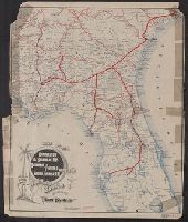
Alternative Title:
Charleston & Savannah Railway, Savannah Florida & Western Railway, South Florida Railway and Charleston & Savannah Ry., Savannah Florida & Western Ry., South Florida Ry.
Description:
Shows railway lines completed and "in course of construction", "Peoples Line" of steamers, and illus.
Publisher:
The Company,
Subject (Name):
Charleston and Savannah Railway, Charleston and Savannah Railway--Maps, Savannah, Florida and Western Railway Company, Savannah, Florida and Western Railway Company--Maps, and South Florida Railroad Company
Subject (Topic):
Railroads--Florida--Maps, Railroads--Georgia--Maps, and Railroads--South Carolina--Maps
Found in:
Beinecke Rare Book and Manuscript Library > Map of the Charleston & Savannah Ry., Savannah Florida & Western Ry., South Florida Ry. : and all of the routes operated by the peoples line of steamers and plant steamship line known as the plant system / Rand Avery Supply Co.