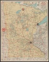
"Texaco road map, 1932, United States," local route maps of Minneapolis-St. Paul and Duluth, distance table, indexes, ill., and text on verso., In lower right: A4 2820., and Includes inset of northeastern Minnesota.
Texaco touring map of California, Nevada. and Texaco touring map of Washington, Oregon.
Description:
"3-4400-27.", "3-4432-29.", "Copyright by Rand McNally & Company.", Date based on gasoline tax table dated Jan. 1954., Includes indexes., Panel title., Relief shown pictorially and by spot heights., and Texaco touring map of Washington, Oregon -- Texaco touring map of California, Nevada.
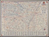
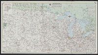
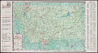
Interstate travel map, north central section. and Interstate travel map, south central section.
Description:
Interstate travel map, north central section -- Interstate travel map, south central section., Panel title., Publication date inferred from advertisement showing 1959 date., and Relief shown by spot heights and pictorially.
Publisher:
Rand McNally,
Subject (Name):
Mobil Oil Company
Subject (Topic):
Roads--Middle West--Maps and Roads--Southern states--Maps
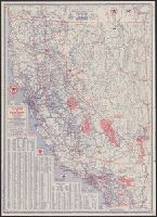
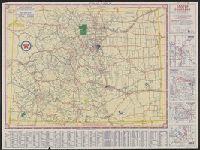
Sectional trip map., Texaco sectional trip map., Texaco touring map of Colorado., and Touring map of Colorado.
Description:
"X 3805" in lower right of Colorado map and "X.4113(N)" in lower right of Sectional trip map., Includes index, 4 local route maps, distance table, and text., Panel title., Relief shown pictorially and by spot heights., and Texaco touring map of Colorado -- Texaco
Publisher:
Rand McNally and Co.,
Subject (Geographic):
Colorado--Maps
Subject (Name):
Texas Company
Subject (Topic):
Roads--Colorado--Maps and Roads--West (U.S.)--Maps
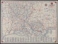
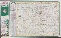
"9-5650-5" on Colorado map and "9-574620V-4" on Denver map., Denver street map -- Colorado., Includes indexes, distance table, and ill., On back panel: 59B., Panel title., and Relief shown by spot heights.
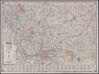
In lower right: X 3624., Indexed., Relief shown by shading and spot heights., and Road maps of Yellowstone National Park and Waterton-Glacier International Peace Park, text, distance table, and col. ill. on verso.