Skip to search
Skip to main content
Skip to first result
Search
You Searched For
Extent of Digitization
Completely digitized
Genre
Maps
Creator
Rand McNally and Company
Subject (Topic)
Railroads--Minnesota--Maps
New Search
Search Results
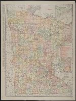
Creator:
Published / Created:
1911
Call Number:
814 1911
Container / Volume:
BRBL_00557
Image Count:
1
Resource Type:
Maps, Atlases & Globes
Abstract:
Shows railroads and counties.
Description:
Includes indexes and insets of "N.E. corner of Minnesota, showing Cook County" and "Minneapolis, St. Paul and vicinity."
Publisher:
Rand, McNally & Co.,
Subject (Geographic):
Minnesota--Maps
Subject (Topic):
Railroads--Minnesota--Maps
Found in:
Beinecke Rare Book and Manuscript Library > Minnesota.
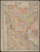
Creator:
Published / Created:
1914
Call Number:
814 1914
Container / Volume:
BRBL_00557
Image Count:
1
Resource Type:
Maps, Atlases & Globes
Description:
annotated in color pencil; verso index covered by backing., Includes insets of "N.E. corner of Minnesota, showing Cook Co." and "Minneapolis, St. Paul and vicinity.", Indexed on verso., and Shows railroads, counties, townships, etc.
Publisher:
Rand McNally & Co.,
Subject (Geographic):
Minnesota--Maps
Subject (Topic):
Railroads--Minnesota--Maps
Found in:
Beinecke Rare Book and Manuscript Library > The Rand-McNally new commercial atlas map of Minnesota.
Branch:v1.61.6 ,Deployed:2024-06-12T09:55:33-04:00