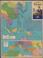
Map of Southern Europe, the Mediterranean area and the Near East., Map of the Far East., War map of Atlantic Ocean area, Eurasia and Africa., War map of Pacific Ocean and the Far East., and War map of the world
Description:
Includes notes, inset of "World time zones," and col. ill., Map of the Far East. Scale [ca. 1:13,000,000] -- Map of Southern Europe, the Mediterranean area and the Near East. Scale [ca. 1:14,500,000] -- Verso: War map of Atlantic Ocean, and On panel title: "B."
Publisher:
Rand McNally & Co.,
Subject (Name):
Thomas, Lowell, 1892-1981
Subject (Topic):
Time--Systems and standards--Maps and World War, 1939-1945--Maps
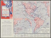
Ancillary maps on verso: [1.] The far east. Scale [ca. 1:40 900 000] at equator -- [2.] Western hemisphere defense map. Scale [ca. 1:35 000 000]. and Legend and dates of war declarations.
Rand McNally and Company Richfield Oil Corporation United States. President (1817-1825 : Monroe). Monroe doctrine. Selections
Published / Created:
1941?]
Call Number:
11hd 1941S
Image Count:
2
Resource Type:
Maps, Atlases & Globes
Alternative Title:
United States defense map and Western Hemisphere strategic bases and Western Hemisphere strategic bases
Description:
"Calendar of world events, 1935-1941"--Lower margin of second map., Includes text of part of the Monroe Doctrine, as declared by President James Monroe in his seventh annual message to Congress on December 2, 1823, on back pane, and United States defense map --
Publisher:
Richfield [Oil Corp.,
Subject (Geographic):
United States--Defenses--Maps, United States--Maps, Western Hemisphere--Defenses--Maps, and Western Hemisphere--Maps
Subject (Topic):
Military bases--United States--Maps, Military bases--Western Hemisphere--Maps, World War, 1939-1945--Maps, and World War, 1939-1945--Western Hemisphere--Maps