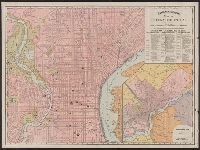
Rand McNally and Co.'s Indexed atlas of the world.
Container / Volume:
BRBL_00500
Image Count:
1
Resource Type:
Maps, Atlases & Globes
Alternative Title:
Philadelphia and vicinity. and Rand McNally & Co.'s new business atlas map of Philadelphia.
Description:
"90, 91.", At head of title and top of map: Rand McNally & Co.'s indexed Atlas of the world., Includes index of piers and their ownership on Delaware River., Inset: Philadelphia and vicinity. Scale [ca. 1:120,000]., and On verso: [part of gazetteer listing for Pe
Publisher:
Rand McNally,
Subject (Geographic):
Philadelphia (Pa.)--Maps and Philadelphia Metropolitan Area (Pa.)--Maps
Subject (Name):
Rand McNally and Company. Rand McNally & Co.'s indexed atlas of the world
Philadelphia and vicinity [cartographic material]. and Rand McNally & Co.'s map showing one hundred miles around Philadelphia.
Description:
Inset map on recto: Philadelphia and vicinity. Scale [ca. 1:116 000]., Map on verso: Rand McNally & Co.'s map showing one hundred miles around Philadelphia. Scale [ca. 1:506 880]. Eight miles to one inc, and Sheet measures 54 x 72 cm. Ms. no. on verso: Egk76 2.
Publisher:
Rand, McNally & Co.,
Subject (Geographic):
Middle Atlantic States--Maps, Philadelphia (Pa.)--Maps, and Philadelphia Metropolitan Area (Pa.)--Maps