
You Searched For
« Previous
| 226 - 233 of 233 |
Next »
Search Results
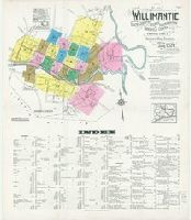
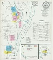
226. Willimantic, including South Coventry, Storrs, South Windham, and Mansfield Center, Windham County, Connecticut.
- Creator:
- Sanborn Map Company, issuing body
- Published / Created:
- 1924
- Call Number:
- 766 W677 1924
- Image Count:
- 26
- Resource Type:
- Maps, Atlases & Globes
- Abstract:
- Sanborn fire insurance maps are a rich source of historic data on the urban built environment of North America during the 19th and early 20th centuries. The atlases were created for the purpose of underwriting fire insurance policies, which depended upon accurate and frequently-updated information about construction materials, municipal and transportation infrastructure, industrial and commercial landuse and more. The Yale University Library Map Department scanned its holdings of Sanborn fire insurance maps (consisting primarily of Connecticut towns) in order to make the maps more accessible.
- Alternative Title:
- June 1924, Willimantic Conn., Willimantic, Connecticut, and Willimantic, Windham County, Connecticut
- Description:
- "26 sheets (1744).", Contains information on population, prevailing winds, water facilities and fire department., Includes index of streets and specials., Partial cadastral map., and SMLMAPL 766 W677 1924: Sheets disbound. "Triplicate" stamp on sheets. Library of Congress copyright stamp on title sheet.
- Subject (Geographic):
- Coventry (Conn.)--Maps, Mansfield Center (Conn.)--Maps, Storrs (Conn.)--Maps, Willimantic (Conn.)--Maps, and Windham (Conn.)--Maps
- Subject (Name):
- Library of Congress Stamp
- Subject (Topic):
- Fire risk assessment--Connecticut--Coventry--Maps, Fire risk assessment--Connecticut--Mansfield Center--Maps, Fire risk assessment--Connecticut--Storrs--Maps, Fire risk assessment--Connecticut--Willimantic--Maps, Fire risk assessment--Connecticut--Windham--Maps, Real property--Connecticut--Coventry--Maps, Real property--Connecticut--Mansfield Center--Maps, Real property--Connecticut--Storrs--Maps, Real property--Connecticut--Willimantic--Maps, and Real property--Connecticut--Windham--Maps
- Found in:
- Beinecke Rare Book and Manuscript Library > Willimantic, including South Coventry, Storrs, South Windham, and Mansfield Center, Windham County, Connecticut.
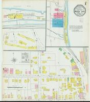
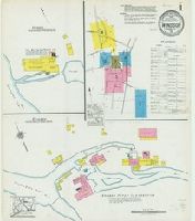
227. Windsor Locks, Hartford Co., Connecticut.
- Creator:
- Sanborn Map Company, issuing body
- Published / Created:
- 1905
- Call Number:
- 766 W728 1905
- Image Count:
- 3
- Resource Type:
- Maps, Atlases & Globes
- Abstract:
- Sanborn fire insurance maps are a rich source of historic data on the urban built environment of North America during the 19th and early 20th centuries. The atlases were created for the purpose of underwriting fire insurance policies, which depended upon accurate and frequently-updated information about construction materials, municipal and transportation infrastructure, industrial and commercial landuse and more. The Yale University Library Map Department scanned its holdings of Sanborn fire insurance maps (consisting primarily of Connecticut towns) in order to make the maps more accessible.
- Alternative Title:
- Nov. 1905, Windsor Locks, Conn.
- Description:
- "8407. 3 sheets.", Contains information on population, prevailing winds, water facilities and fire department., Partial cadastral map., and SMLMAPL 766 W728 1905: Sheets disbound. "Triplicate" stamp on all sheets. Library of Congress copyright stamp on title sheet.
- Subject (Geographic):
- Windsor Locks (Conn.)--Maps
- Subject (Name):
- Library of Congress Stamp
- Subject (Topic):
- Fire risk assessment--Connecticut--Windsor Locks--Maps and Real property--Connecticut--Windsor Locks--Maps
- Found in:
- Beinecke Rare Book and Manuscript Library > Windsor Locks, Hartford Co., Connecticut.

228. Windsor Locks, Hartford County, Connecticut.
- Creator:
- Sanborn Map Company, issuing body
- Published / Created:
- 1912
- Call Number:
- 766 W728 1912
- Image Count:
- 6
- Resource Type:
- Maps, Atlases & Globes
- Abstract:
- Sanborn fire insurance maps are a rich source of historic data on the urban built environment of North America during the 19th and early 20th centuries. The atlases were created for the purpose of underwriting fire insurance policies, which depended upon accurate and frequently-updated information about construction materials, municipal and transportation infrastructure, industrial and commercial landuse and more. The Yale University Library Map Department scanned its holdings of Sanborn fire insurance maps (consisting primarily of Connecticut towns) in order to make the maps more accessible.
- Alternative Title:
- Feb. 1912, Windsor Locks, Conn.
- Description:
- "4671. (6 sheets).", Contains information on population, prevailing winds, water facilities and fire department., Includes index of streets and specials., Partial cadastral map., and SMLMAPL 766 W728 1912: Sheets disbound. Library of Congress copyright stamp on title sheet.
- Subject (Geographic):
- Windsor Locks (Conn.)--Maps
- Subject (Name):
- Library of Congress Stamp
- Subject (Topic):
- Fire risk assessment--Connecticut--Windsor Locks--Maps and Real property--Connecticut--Windsor Locks--Maps
- Found in:
- Beinecke Rare Book and Manuscript Library > Windsor Locks, Hartford County, Connecticut.
229. Windsor Locks, Hartford County, Connecticut.
- Creator:
- Sanborn Map Company, issuing body
- Published / Created:
- 1925
- Call Number:
- 766 W728 1925
- Image Count:
- 7
- Resource Type:
- Maps, Atlases & Globes
- Abstract:
- Sanborn fire insurance maps are a rich source of historic data on the urban built environment of North America during the 19th and early 20th centuries. The atlases were created for the purpose of underwriting fire insurance policies, which depended upon accurate and frequently-updated information about construction materials, municipal and transportation infrastructure, industrial and commercial landuse and more. The Yale University Library Map Department scanned its holdings of Sanborn fire insurance maps (consisting primarily of Connecticut towns) in order to make the maps more accessible.
- Alternative Title:
- July 1925, Windsor Locks, Conn.
- Description:
- "(2356). (7 sheets).", Contains information on population, prevailing winds, water facilities and fire department., Includes index of streets and specials., Partial cadastral map., Sheets 1-3 at scale 1:600 ; sheets 4-7 at scale 1:1,200., and SMLMAPL 766 W728 1925: Sheets disbound. Library of Congress copyright stamp on title sheet.
- Subject (Geographic):
- Windsor Locks (Conn.)--Maps
- Subject (Name):
- Library of Congress Stamp
- Subject (Topic):
- Fire risk assessment--Connecticut--Windsor Locks--Maps and Real property--Connecticut--Windsor Locks--Maps
- Found in:
- Beinecke Rare Book and Manuscript Library > Windsor Locks, Hartford County, Connecticut.
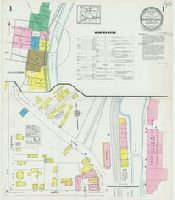
230. Windsor, Hartford County, Connecticut.
- Creator:
- Sanborn Map Company, issuing body
- Published / Created:
- 1921
- Call Number:
- 766 W725 1921
- Image Count:
- 9
- Resource Type:
- Maps, Atlases & Globes
- Abstract:
- Sanborn fire insurance maps are a rich source of historic data on the urban built environment of North America during the 19th and early 20th centuries. The atlases were created for the purpose of underwriting fire insurance policies, which depended upon accurate and frequently-updated information about construction materials, municipal and transportation infrastructure, industrial and commercial landuse and more. The Yale University Library Map Department scanned its holdings of Sanborn fire insurance maps (consisting primarily of Connecticut towns) in order to make the maps more accessible.
- Alternative Title:
- Apr. 1921, Windsor, Conn.
- Description:
- "9 sheets. (3761).", Contains information on population, prevailing winds, water facilities and fire department., Includes index of streets and specials., Partial cadastral map., Sheets 1-4 and 9 at scale 1:600 ; sheets 5-8 at scale 1:1,200., and SMLMAPL 766 W725 1921: Sheets disbound. Library of Congress copyright stamp on title sheet.
- Subject (Geographic):
- Windsor (Conn.)--Maps
- Subject (Name):
- Library of Congress Stamp
- Subject (Topic):
- Fire risk assessment--Connecticut--Windsor--Maps and Real property--Connecticut--Windsor--Maps
- Found in:
- Beinecke Rare Book and Manuscript Library > Windsor, Hartford County, Connecticut.
231. Windsor, Hartford County, Connecticut.
- Creator:
- Sanborn Map Company, issuing body
- Published / Created:
- 1927
- Call Number:
- 766 W725 1927
- Image Count:
- 11
- Resource Type:
- Maps, Atlases & Globes
- Abstract:
- Sanborn fire insurance maps are a rich source of historic data on the urban built environment of North America during the 19th and early 20th centuries. The atlases were created for the purpose of underwriting fire insurance policies, which depended upon accurate and frequently-updated information about construction materials, municipal and transportation infrastructure, industrial and commercial landuse and more. The Yale University Library Map Department scanned its holdings of Sanborn fire insurance maps (consisting primarily of Connecticut towns) in order to make the maps more accessible.
- Alternative Title:
- July 1927, Windsor, Conn.
- Description:
- "(3196). (11 sheets).", Contains information on population, prevailing winds, water facilities and fire department., Includes index of streets and specials., Partial cadastral map., Sheets 3-4 and 11 at scale 1:600 ; sheets 1-2 and 5-10 at scale 1:1,200., and SMLMAPL 766 W725 1927: Sheets disbound. Library of Congress copyright stamp on title sheet.
- Subject (Geographic):
- Windsor (Conn.)--Maps
- Subject (Name):
- Library of Congress Stamp
- Subject (Topic):
- Fire risk assessment--Connecticut--Windsor--Maps and Real property--Connecticut--Windsor--Maps
- Found in:
- Beinecke Rare Book and Manuscript Library > Windsor, Hartford County, Connecticut.
232. Winsted, Litchfield County, Connecticut.
- Creator:
- Sanborn Map Company, issuing body
- Published / Created:
- 1919
- Call Number:
- 766 W73 1919
- Image Count:
- 22
- Resource Type:
- Maps, Atlases & Globes
- Abstract:
- Sanborn fire insurance maps are a rich source of historic data on the urban built environment of North America during the 19th and early 20th centuries. The atlases were created for the purpose of underwriting fire insurance policies, which depended upon accurate and frequently-updated information about construction materials, municipal and transportation infrastructure, industrial and commercial landuse and more. The Yale University Library Map Department scanned its holdings of Sanborn fire insurance maps (consisting primarily of Connecticut towns) in order to make the maps more accessible.
- Alternative Title:
- Aug. 1919, Winsted, Conn.
- Description:
- "23 sheets (2780).", Contains information on population, prevailing winds, water facilities and fire department., Includes index of streets and specials., Missing first sheet with index map., Partial cadastral map., and SMLMAPL 766 W73 1919: Imperfect: Original title sheet wanting; photocopy included. Sheets disbound. "Triplicate" stamp on sheets. Library of Congress copyright stamp on title sheet.
- Subject (Geographic):
- Winsted (Conn.)--Maps
- Subject (Name):
- Library of Congress Stamp
- Subject (Topic):
- Fire risk assessment--Connecticut--Winsted--Maps and Real property--Connecticut--Winsted--Maps
- Found in:
- Beinecke Rare Book and Manuscript Library > Winsted, Litchfield County, Connecticut.

233. Winsted, Litchfield County, Connecticut.
- Creator:
- Sanborn Map Company, issuing body
- Published / Created:
- 1931
- Call Number:
- 766 W73 1931
- Image Count:
- 23
- Resource Type:
- Maps, Atlases & Globes
- Abstract:
- Sanborn fire insurance maps are a rich source of historic data on the urban built environment of North America during the 19th and early 20th centuries. The atlases were created for the purpose of underwriting fire insurance policies, which depended upon accurate and frequently-updated information about construction materials, municipal and transportation infrastructure, industrial and commercial landuse and more. The Yale University Library Map Department scanned its holdings of Sanborn fire insurance maps (consisting primarily of Connecticut towns) in order to make the maps more accessible.
- Alternative Title:
- Jan. 1931, Winsted, Conn. and Winsted, Litchfield County, Connecticut, including Riverton
- Description:
- "(1087) (23 sheets).", Contains information on population, prevailing winds, water facilities and fire department., Includes index of streets and specials., Partial cadastral map., and SMLMAPL 766 W73 1931: Sheets disbound. "Triplicate" stamp on sheets. Library of Congress copyright stamp on title sheet.
- Subject (Geographic):
- Winsted (Conn.)--Maps
- Subject (Name):
- Library of Congress Stamp
- Subject (Topic):
- Fire risk assessment--Connecticut--Winsted--Maps and Real property--Connecticut--Winsted--Maps
- Found in:
- Beinecke Rare Book and Manuscript Library > Winsted, Litchfield County, Connecticut.