- Creator:
- Sanson, Nicolas, 1600-1667
- Published / Created:
- 1650
- Call Number:
- 71 1650
- Container / Volume:
- BRBL_00360
- Image Count:
- 1
- Resource Type:
- Maps, Atlases & Globes
- Alternative Title:
- Ameriqve septentrionale
- Description:
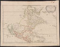
- Covers area from northern South America to Greenland and includes the British Isles and the Azores., McLaughlin third state, with Lake Ontario shaded. Mounted on board. Sheet measures 47 x 61 cm. Ms. nos. on recto: 42, 28., Relief shown pictorially., and Shows C
- Publisher:
- Chez l'autheur, et chez Pierre Mariette, rue S. Iacques a l'Esperāce,
- Subject (Geographic):
- North America--Maps--Early works to
- Subject (Name):
- Mariette, Pierre, 1603-1657 and Peyrounin, A., engraver
- Found in:
- Beinecke Rare Book and Manuscript Library > Amerique septentrionale / par N. Sanson d'Abbeville Geog. du Roy. ; A. Peyrounin sculp.
Search
Limit your search
- Public✖[remove]2
- cartographic✖[remove]2
- Sanson, Nicolas, 1600-1667✖[remove]2
- Mariette, Pierre, 1603-1657✖[remove]2
- Peyrounin, A., engraver1
- Somer, Jan1
Current results range from 1650 to 1656