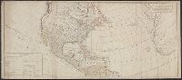
Bowen, Emanuel, d. 1767 Gibson, J. (John) Overton, Henry, fl. 1706-1764 Sayer, Robert, 1725-1794
Published / Created:
[between 1755 and 1775?]
Call Number:
2003 Folio 85
Image Count:
1
Description:
BEIN 2003 Folio 85: No. 4 of 45 maps bound together with binder's spine title: Atlas of America; ms. table of contents. Bookplate of Paul Mellon., by Eman. Bowen, geogr. to His Majesty, and John Gibson, engraver., Hand-colored., Includes text and insets of A particular map of Baffin and Hudson's Bay and The passage by land to California, discovered by Father Eusebius Francis Kino ...., Relief shown pictorially., Scale [ca. 1:5,500,000]., and Shows boundaries, cities and towns, roads, forts, missions, some industries, trails, trade routes, portages, and vegetation. Also shows Indian villages and tribal territories, routes of navigation in the Gulf of Mexico, and navigational hazards along the coast.
Publisher:
Printed for Robt. Sayer opposite Fetter Lane Fleet Street
Includes table of "The continent and islands of America are divided and possessed as follows viz." and May be part of a map attributed to R. Sayer, based on maps by d'Anville and materials by Thomas Pownall; first issued in 1763 by J. Gibson and reissued over
Publisher:
s.n.,
Subject (Geographic):
NorthAmerica--Maps--Early works to
Subject (Name):
Anville, Jean Baptiste Bourguignon d', 1697-1782, Gibson, J. (John), and Pownall, Thomas, 1722-1805
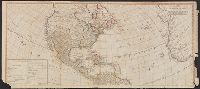
Includes table of "The continent and islands of America are divided and possessed as follows viz.", Prime meridian: Ferro., and Probably part of a map attributed to R. Sayer, based on maps by d'Anville and materials by Thomas Pownall; first issued in 1763 by J.
Publisher:
s.n.,
Subject (Geographic):
NorthAmerica--Maps--Early works to
Subject (Name):
Anville, Jean Baptiste Bourguignon d', 1697-1782, Gibson, J. (John), and Pownall, Thomas, 1722-1805