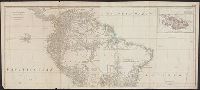
Also appeared in Kitchin's General atlas describing the whole universe. London : Printed for Robert Sayer, [1780]., Includes descriptive notes and text "Division of South America with a summary account of its trade," and large ornamental cartouche., Inset map: Chart of the Falkland's Islands : named by the French Malouine Islands, and discovered by Hawkins in the year 1595. Scale [ca. 1:2,000,000]., Prime meridian: Ferro., Relief shown pictorially; depths by soundings., Sheets measures 54 x 122.7 cm., and Sheets mounted together to form 2 sheets.
Publisher:
Printed for Robert Sayer,
Subject (Geographic):
Falkland Islands--Maps--Early works to 1800 and South America--Maps--Early works to 1800
Subject (Name):
Anville, Jean Baptiste Bourguignon d', 1697-1782, Kitchin, Thomas, d. 1784, and Kitchin, Thomas, d. 1784. General atlas describing the whole universe
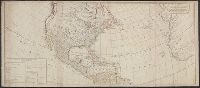
Also shows anchorages, currents, and routes of navigation along the coast., Includes historical notes, text, 10 insets of harbors, and a table showing that "North America is divided into the continent & the islands" according to geography and politics., and Rel
Publisher:
Printed for Robt. Sayer,
Subject (Geographic):
North America--Maps--Early works to 1800
Subject (Name):
Anville, Jean Baptiste Bourguignon d', 1697-1782 and Robert de Vaugondy, Didier, 1723-1786
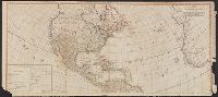
Includes table of "The continent and islands of America are divided and possessed as follows viz." and May be part of a map attributed to R. Sayer, based on maps by d'Anville and materials by Thomas Pownall; first issued in 1763 by J. Gibson and reissued over
Publisher:
s.n.,
Subject (Geographic):
America--Maps--Early works to 1800 and North America--Maps--Early works to 1800
Subject (Name):
Anville, Jean Baptiste Bourguignon d', 1697-1782, Gibson, J. (John), and Pownall, Thomas, 1722-1805
Includes table of "The continent and islands of America are divided and possessed as follows viz.", Prime meridian: Ferro., and Probably part of a map attributed to R. Sayer, based on maps by d'Anville and materials by Thomas Pownall; first issued in 1763 by J.
Publisher:
s.n.,
Subject (Geographic):
America--Maps--Early works to 1800 and North America--Maps--Early works to 1800
Subject (Name):
Anville, Jean Baptiste Bourguignon d', 1697-1782, Gibson, J. (John), and Pownall, Thomas, 1722-1805