Search
You Searched For
Search Results
- Creator:
- U.S. Coast and Geodetic Survey
- Published / Created:
- 1944
- Call Number:
- 50 1945I
- Container / Volume:
- BRBL_00273
- Image Count:
- 2
- Resource Type:
- Maps, Atlases & Globes
- Description:
- Cloth map.
- Publisher:
- Amy Map Service,
- Subject (Geographic):
- Kunming Region (China)--Maps
- Subject (Name):
- United States. Aeronautical Chart Service, United States. Army Air Forces, and United States. Army Map Service
- Subject (Topic):
- Military maps
- Found in:
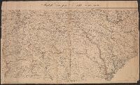
- Beinecke Rare Book and Manuscript Library > AAF cloth chart. No. 133, Kun-Ming, Yunnan, China to Chabua, Assam, India Forces / prepared under the direction of the Commanding General, Army Air Forces, for the Aeronautical Chart Service, by the U.S. Coast and Geodetic Survey, Washington, D.C., Januar
- Creator:
- U.S. Coast and Geodetic Survey
- Published / Created:
- 1944
- Call Number:
- 50 1945I
- Container / Volume:
- BRBL_00273
- Image Count:
- 2
- Resource Type:
- Maps, Atlases & Globes
- Description:
- Cloth map.
- Publisher:
- Amy Map Service,
- Subject (Geographic):
- Kunming Region (China)--Maps
- Subject (Name):
- United States. Aeronautical Chart Service, United States. Army Air Forces, and United States. Army Map Service
- Subject (Topic):
- Military maps
- Found in:
- Beinecke Rare Book and Manuscript Library > AAF cloth chart. No. 133, Kun-Ming, Yunnan, China to Chabua, Assam, India Forces / prepared under the direction of the Commanding General, Army Air Forces, for the Aeronautical Chart Service, by the U.S. Coast and Geodetic Survey, Washington, D.C., Januar
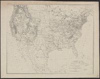
- Creator:
- U.S. Coast and Geodetic Survey
- Published / Created:
- 1880
- Call Number:
- 75AK 1880
- Container / Volume:
- BRBL_00407A
- Image Count:
- 1
- Resource Type:
- Maps, Atlases & Globes
- Publisher:
- U.S. Coast and Geodetic Survey,
- Subject (Geographic):
- United States--Maps
- Found in:
- Beinecke Rare Book and Manuscript Library > Base-map of the United States / Drawn and engraved by A. and H. Lindenkohl.
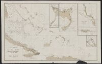
- Creator:
- U.S. Coast and Geodetic Survey
- Published / Created:
- [1881]
- Call Number:
- 851 1881
- Container / Volume:
- BRBL_00639
- Image Count:
- 1
- Resource Type:
- Maps, Atlases & Globes
- Description:
- Imperfect. Chipped with possible loss of text.
- Publisher:
- U.S. Coast and Geodetic Survey,
- Subject (Geographic):
- Bahamas--Discovery and exploration--Maps and Bahamas--Maps
- Subject (Name):
- Columbus, Christopher--Travel--Caribbean Area--Maps
- Found in:
- Beinecke Rare Book and Manuscript Library > Chart of part of the Bahama Islands showing the tracks ascribed to Columbus on his discovery of the New World / compiled and drawn, under the direction of W.T. Bright, in charge of Drawing Division, U.S. Coast and Geodetic Survey Office ; by T.J. O'Sulliv
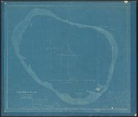
- Creator:
- Jensen, Carl C
U.S. Coast and Geodetic Survey
- Published / Created:
- 1893?]
- Call Number:
- 23 C61 1893
- Container / Volume:
- BRBL_00020
- Image Count:
- 1
- Resource Type:
- Maps, Atlases & Globes
- Description:
- Blueprint.
- Publisher:
- United States Coast & Geodetic Survey?
- Subject (Geographic):
- Clipperton Island--Maps
- Found in:
- Beinecke Rare Book and Manuscript Library > Clipperton Island, North Pacific Ocean / surveyed 1893 by Carl C. Jensen.
- Creator:
- U.S. Coast and Geodetic Survey
- Published / Created:
- 1900
- Call Number:
- 767cea 1900
- Container / Volume:
- BRBL_00476
- Image Count:
- 1
- Resource Type:
- Maps, Atlases & Globes
- Alternative Title:
- Connecticut River, Connecticut River, Deep River to Higganum, U.S.C. & G.S. (Series) ; 254., and U.S.C. & G.S. ; 254
- Description:
- "Date of first publication 1895."
- Publisher:
- U.S. Coast and Geodetic Survey,
- Subject (Geographic):
- Connecticut River--Navigation
- Subject (Topic):
- Nautical charts--Connecticut River
- Found in:
- Beinecke Rare Book and Manuscript Library > Connecticut River, Deep River to Higganum, Connecticut / U.S. Coast and Geodetic Survey.
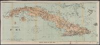
- Creator:
- U.S. Coast and Geodetic Survey
- Published / Created:
- 1898
- Call Number:
- 855hc 1898Q
- Container / Volume:
- BRBL_00765
- Image Count:
- 1
- Resource Type:
- Maps, Atlases & Globes
- Description:
- "482."
- Publisher:
- The Survey,
- Subject (Geographic):
- Cuba--Maps
- Subject (Topic):
- Nautical charts--Cuba
- Found in:
- Beinecke Rare Book and Manuscript Library > Cuba : part of chart "E" / Treasury Department, U.S. Coast and Geodetic Survey, Henry S. Pritchett, Superintendent.
- Creator:
- U.S. Coast and Geodetic Survey
- Published / Created:
- [1861?]
- Call Number:
- 754 1861C
- Container / Volume:
- BRBL_00416
- Image Count:
- 1
- Resource Type:
- Maps, Atlases & Globes
- Description:
- ["Chas. G. Krebs, Lith."]
- Publisher:
- U.S. Coast Survey,
- Subject (Geographic):
- Georgia--Maps and South Carolina--Maps
- Subject (Name):
- Krebs, Charles G and Lindenkohl, A
- Found in:
- Beinecke Rare Book and Manuscript Library > Middle Georgia & South Carolina.
- Creator:
- U.S. Coast and Geodetic Survey
- Published / Created:
- 1886
- Call Number:
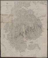
- 761cea M86 1882
- Container / Volume:
- BRBL_00449
- Image Count:
- 1
- Resource Type:
- Maps, Atlases & Globes
- Alternative Title:
- Map ; no. 292, plate no. 1686 and Map ; no. 292, plate no. 1686.
- Description:
- Aids to navigation corrected to 1886.
- Publisher:
- U.S. Coast and Geodetic Survey,
- Subject (Geographic):
- Mount Desert Island (Me.)--Geography--Maps
- Found in:
- Beinecke Rare Book and Manuscript Library > Mount Desert Island, Maine, 1882.