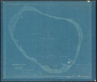
Blueprint. and Handwritten on original, following author's name: Who has kindly permitted this tracing to be taken for the use of the United States Coast & Geodetic Survey.
Connecticut River, Connecticut River, Deep River to Higganum, U.S.C. & G.S. (Series) ; 254., and U.S.C. & G.S. ; 254
Description:
"Date of first publication 1895.", "Electrotype copy no. 1 U.S.C. & G.S."--Upper right margin., "Soundings in feet.", Depths shown by shading and soundings., Includes tidal information., Oriented with north toward upper right corner., Plate no. 2659., and Relief sho
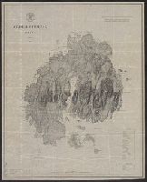
Coast chart ; no. 103(2), Mount Desert Island Maine, and U.S.C. & G.S. (Series) ; no. 103(2)
Description:
Includes a chart of heights of mountains and hills above mean high water, a chart of summer level of lakes and ponds above mean high water, and latitude and longitude of Baker's I Light House and Mt. Desert light on Green Mt. and Relief shown by hachures.
Publisher:
U.S. Coast and Geodetic Survey,
Subject (Geographic):
Maine--Maps
Subject (Name):
Donn, J. W. (John W.), 1835-1905, Hilgard, J. E. (Julius Erasmus), 1825-1891, and Patterson, C. P. (Carlile Pollock), 1816-1881
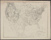
Cape Flattery to Dixon entrance., Dixon entrance to Cape St. Elias., and Northwest coast of America
Description:
Date below scale: 1868., In upper margin of sheet no. 2: No. 701 ... plate no. 1880., In upper right margins: Electrotype copy no. 1 U.S.C.&G.S., and Sheet no. 1. Cape Flattery to Dixon entrance -- Sheet no. 2. Dixon entrance to Cape St. Elias : compiled from Br
Publisher:
U.S. Coast and Geodetic Survey?,
Subject (Geographic):
Pacific Coast (Alaska)--Maps and Pacific Coast (B.C.)--Maps
Subject (Name):
Dall, William Healey, 1845-1927, Davidson, George, 1825-1911, and Nichols, H. E. (Henry Ezra)