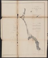
Peirce, Benjamin, 1809-1880 United States Coast Survey
Published / Created:
1869
Call Number:
846cea Or4 1869
Container / Volume:
BRBL_00623
Image Count:
1
Resource Type:
Maps, Atlases & Globes
Description:
In upper left margin: No. 16., Includes notes., Relief shown by hachures. Depths shown by soundings., and Removed from: United States Coast Survey, Annual report of the superintendent of the Coast Survey (1869).
Publisher:
U.S. Coast Survey,
Subject (Geographic):
Blanco, Cape (Or.)--Maps and Port Orford (Or.)--Maps
Subject (Name):
United States Coast Survey. Annual report of the superintendent of the Coast Survey. 1869
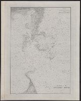
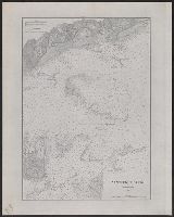
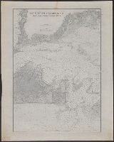
"Plate No. 1446.", Also shows tide rips, direction and strength of currents, and shoals on George's Bank and Cashe's Ledge., and Depths shown by soundings, isolines, form lines, and shading.
Publisher:
The Survey,
Subject (Geographic):
Maine, Gulf of--Maps and North Atlantic Ocean--Maps
Subject (Topic):
Nautical charts--Maine, Gulf of and Nautical charts--North Atlantic Ocean