Search
You Searched For
Search Results
- Creator:
- United States. Army Map Service
- Published / Created:
- 1945
- Call Number:
- 273 T171 1945
- Container / Volume:
- BRBL_00023B
- Image Count:
- 1
- Resource Type:
- Maps, Atlases & Globes
- Alternative Title:
- A.M.S. T736 A, Series (Standard map series designation system) ; T736 A., and Tarakan
- Description:
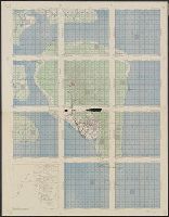
- Map of Tarakan Island divided into 11 charts overlayed with grids and ancillary "index map of air support charts, Tarakan".
- Publisher:
- The Service,
- Subject (Geographic):
- Tarakan Island (Indonesia)--Maps
- Found in:
- Beinecke Rare Book and Manuscript Library > [Air support charts, Tarakan] / prepared and reproduced by Army Map Service.