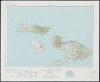
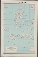
Geological Survey (U.S.) United States. Army Map Service
Published / Created:
1974
Call Number:
234 1974
Container / Volume:
BRBL_00020
Image Count:
1
Resource Type:
Maps, Atlases & Globes
Alternative Title:
Series (Standard map series designation system) ; W532. and Series , W532
Description:
"10,000-meter Universal Mercator grid ticks, zones 4 and 5, international spheroid, shown in blue.", "Hawaiian Islands 1:250,000"--Upper margin., "Maui, Hawaii"--Lower margin., "NF 4-16" -- Upper margin., "Prepared by the Army Map S, and Includes location diagram.
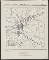
Publisher:
For sale by the Survey, and U.S. Geological Survey ;
Its A.M.S. 9101 and Series (Standard map series designation system) ; 9101.
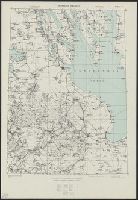
Description:
"Mercator projection.", Elevations are shown by hachures and spot heights in meters., Inset shows area of detailed transportation information., and Roads and trails are shown.
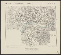
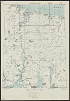
Great Britain. War Office. General Staff. Geographical Section United States. Army Map Service
Published / Created:
1942
Call Number:
352gme M94 1942A
Container / Volume:
BRBL_00111
Image Count:
1
Resource Type:
Maps, Atlases & Globes
Alternative Title:
Geographical Section, General Staff ; no. 4224 and GSGS (Series) ; no. 4224.
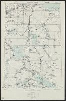
Description:
Five classes of roads and paths are also indicated., In lower left corner of margin: War Office 1941., and In lower right corner of margin: Reproduced from a Finnish map.
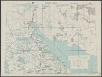
Great Britain. War Office. General Staff. Geographical Section United States. Army Map Service
Published / Created:
[19]44.
Call Number:
352gme M94 1944
Container / Volume:
BRBL_00111
Image Count:
1
Resource Type:
Maps, Atlases & Globes
Alternative Title:
Geographical Section, General Staff ; no. 4224 and GSGS (Series) ; no. 4224.
Description:
Below imprint: 9-44., Five classes of roads and paths are also indicated., In lower left corner of margin: War Office 1941., and In lower right corner of margin: Reproduced from a Finnish map.
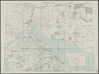
Great Britain. War Office. General Staff. Geographical Section United States. Army Map Service
Published / Created:
1942
Call Number:
352gme M94 1942B
Container / Volume:
BRBL_00111
Image Count:
1
Resource Type:
Maps, Atlases & Globes
Alternative Title:
Geographical Section, General Staff ; no. 4224 and GSGS (Series) ; no. 4224.
Description:
Five classes of roads and paths are also indicated., In lower left corner of margin: War Office 1941., and In lower right corner of margin: Reproduced from a Finnish map.
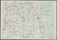
Great Britain. War Office. General Staff. Geographical Section United States. Army Map Service
Published / Created:
1942
Call Number:
352gme M94 1942C
Container / Volume:
BRBL_00111
Image Count:
1
Resource Type:
Maps, Atlases & Globes
Alternative Title:
Geographical Section, General Staff ; no. 4224 and GSGS (Series) ; no. 4224.
Description:
Five classes of roads and paths are also indicated., In lower left corner of margin: War Office 1941., and In lower right corner of margin: Reproduced from a Finnish map.
Great Britain. War Office. General Staff. Geographical Section United States. Army Map Service
Published / Created:
1942
Call Number:
352gme M94 1942D
Container / Volume:
BRBL_00111
Image Count:
1
Resource Type:
Maps, Atlases & Globes
Alternative Title:
Geographical Section, General Staff ; no. 4224 and GSGS (Series) ; no. 4224.
Description:
Five classes of roads and paths are also indicated., In lower left corner of margin: War Office 1941., and In lower right corner of margin: Reproduced from a Finnish map.
Great Britain. War Office. General Staff. Geographical Section United States. Army Map Service
Published / Created:
1942
Call Number:
352gme M94 1942E
Container / Volume:
BRBL_00111
Image Count:
1
Resource Type:
Maps, Atlases & Globes
Alternative Title:
Geographical Section, General Staff ; no. 4224 and GSGS (Series) ; no. 4224.
Description:
Five classes of roads and paths are also indicated., In lower left corner of margin: War Office 1941., and In lower right corner of margin: Reproduced from a Finnish map.